Jugendwanderweg "Hagebuttenrunde"


- 3:45 h
- 14.79 km
- 259 m
- 259 m
- 203 m
- 424 m
- 221 m
- Start: Hiking information point Langeland
- Destination: Hiking information point Langeland
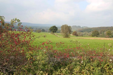
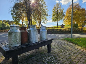
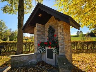
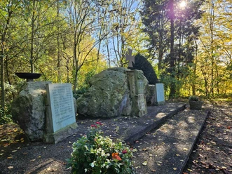
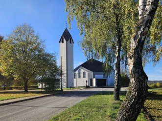
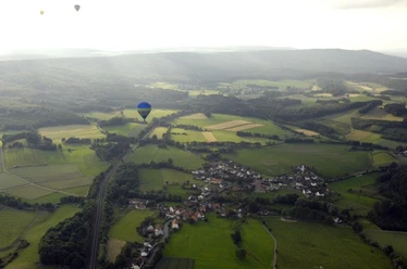
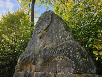
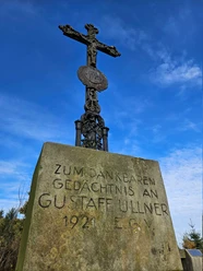
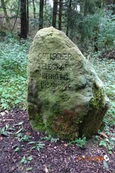
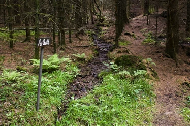
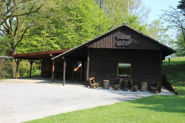
We start our tour at the hiking information point in Langeland. From there, we walk through the pretty village, past 500-year-old oak trees and rosehip bushes along the way. Near "Dickes Bruch" in Erpentrup, we have a magnificent view of the rosehip country and the Eggegebirgskamm ridge. We reach the Emmer river through a small wood and walk leisurely through Erpentrup. The path leads us past historic milk churns and an old manor/ehm. Glassworks. Passing the memorial to the fallen soldiers, we reach the Bodostein. The stone was erected in memory of Count Bodo von Oeynhausen, who died of an incurable brain disease in 1910, on the forest path in the Eggegebirge mountains near Langeland. Count Bodo von Oeynhausen is said to have killed a large four-toed stag at this spot. The huge stones come from Velmerstot and were brought here by Driburg carters with wagons and six horses. The trail continues uphill through the beautiful forest to the Black Cross. According to legend, a charcoal burner was plundered here by a group of marauders during the Thirty Years' War, impaled on logs in the shape of a cross and placed in a smoking pile, where the poor man was found the next day charred as a "black cross". Since this atrocity, the forest area has been called the "Black Cross". Here we can finally eat the provisions we have brought with us. We continue up the hill to the Rehberghütte, where a telegraph station used to be built. We then walk leisurely through the spring area past the Aa spring and come across the popular Emmer spring. The Emmer is a tributary of the Weser, rises at this spring and flows into the Weser after 62 km in Emmerthal near Hameln. Immediately afterwards, our hike takes us through rosehip country to the Eggegebirgshütte in Langeland, which is run by the Erpentrup-Langeland section of the Eggegebirgsverein and has a playground, barbecue and camping area. The hut is a solid building with gas heating, electricity, running water, toilets and a shower. Overnight stays are also possible in the hut with sleeping bags and air mattresses (www.eggegebirgsverein.de). From here, we return to our starting point after a short time.
Alternatively, you can also reach the Hagebuttenweg via an access route (X8) from Altenbeken, Bahnhof to the Rehberghütte/ehm. Telegraph station and also a combination to the observation tower at Vermerstot are possible.


Waypoints
Good to know
Pavements
Best to visit
Tour information
Loop Road
Equipment
Don't forget your picnic rucksack. You won't find any refreshment stops along the way, but there are plenty of idyllic places to take a break!
We recommend sturdy footwear.
Directions & Parking facilities
Bad Driburg has its own train stop and is integrated into the existing hourly NordWestBahn timetable.
You can get to the starting point at the hiking information point in the Langeland district of Bad Driburg with the R75 Bad Driburg - Nieheim and R76 Bad Driburg - Steinheim bus services. You can download the bus timetables here.
Always know what's running: The smart number for buses and trains in NRW 01803 504030 (timetable information for €0.09/min from a German landline, mobile max. €0.42/min) or online at www.fahr-mit.de.
License (master data)
Bad Driburger Touristik GmbH

Author´s Tip / Recommendation of the author
Go on a modern treasure hunt! Eleven small geocaches are hidden along the trail, which you have to find using a GPS device or an app. Once the treasure has been found, you enter your name and date in the logbook and hide the small cans again for the next discoverer.
You can download the geocaching app here.
Map
Tourist map Bad Driburg on a scale of 1:20,000 (hiking and cycling map, walking routes & city map)
Eggegebirge (northern part) - Eggegebirgsverein hiking map 63 at a scale of 1:25,000
Both available from Bad Driburger Touristik GmbH
Download GPX file
Photo Gallery


