Paderborner Karstrundweg - Vom Ellerbachtal auf die Hochfläche


- 3:30 h
- 12.82 km
- 224 m
- 205 m
- 207 m
- 324 m
- 117 m
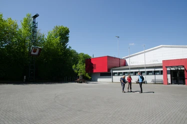
- Start: Paderborn-Dahl, multi-purpose hall
- Destination: Paderborn-Dahl, multi-purpose hall
The starting point of the Paderborn Karstrundweg trail is at the multi-purpose hall and sports facilities on Grundsteinheimer Weg. From there, it runs past the cemetery to the parish church and then along the Ellerbach stream to the west. You soon leave the village behind you and enjoy beautiful views of the Ellerbach valley. In summer, the stream carries no water, as it seeps away in so-called "Schwalglöchern" or "Bachschwinden".
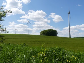
The path then climbs uphill, crosses the district road and then runs through the forest for quite some distance along the approximately 700-metre-long Dahler Skulpturenpfad, which features six works of art made of oak wood or a combination of oak wood, steel or stone. Once you reach the edge of the forest, the view sweeps unexpectedly over the vast Paderborn plateau. At 324 meters, the Knipsberg is the highest point of the tour. The groups of trees that can be seen on the farmland are sinkholes, i.e. collapsed underground cavities. "Spielmanns Kuhle", the largest sinkhole here, has a diameter of around 40 and a depth of 15 meters.
In the Merschetal valley, a "wilderness area" in the forest, which should not be entered, is the reason for a "detour". Once you reach the edge of the forest, there are once again beautiful views of Dahl before you reach the multi-purpose hall again.

Waypoints

Good to know
Pavements
Best to visit
Directions
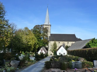
From the multi-purpose hall, we first follow Grundsteinheimer Weg downhill. After a few meters, behind the tennis courts, we turn diagonally left onto an asphalt path that can be closed off with a barrier. About 70 meters further on, we turn left onto the paved footpath. We follow this through a 90-degree right-hand bend and walk downhill past the cemetery to the parish church of St. Margaretha, which we can clearly see in front of us thanks to its 47-metre-high church tower.
We cross Schlotmannstraße at the pedestrian lights. On the right, we see an information board about the parish church and the Dahl district. We descend the stairs, cross the street Zum Deich and walk straight ahead into Ellersteg. Immediately after the bridge over the canalized Ellerbach, we turn left. On the Tiefer Weg road, we walk along the concrete stream bed and reach a fork in the path at a stone cross. We keep slightly to the right, staying on the Tiefer Weg and walking uphill. At the next fork, we turn left onto the narrow asphalt path. This runs slightly higher along the Ellerbach valley. We stay on the narrow asphalt path for around 600 meters. After just under 300 meters, we pass a huge bench, the largest in the Paderborn region, which was erected there in 2022.
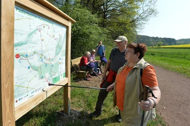
At the T-junction, we turn left, walk steeply downhill for about 100 meters and turn right at the crossroads onto the gravel path. We now walk along the grit path for about a quarter of an hour and see an information board about the Ellerbach after about 800 meters. About 200 meters before the end of the grit path, we again come across an overview board of the Karstrundweg, as we have already seen at the church. At the end of the grit path, we continue to the left on the asphalt path. We cross the mostly dry Ellerbach stream. As a typical watercourse of the Paderborn plateau, it seeps away here in this area and between Schwaney and Dahl in the fissured limestone of the subsoil in so-called "Bachschwinden". It only carries water on the surface after abundant rainfall.
We walk uphill, turn left after the farm onto the Grundweg and walk past the pastures of the "Alpacas in Ellertal". An information board reveals interesting facts about these fluffy animals.
After about 450 meters, just before a clear-cut area, we turn right and hike gently uphill. After about 15 minutes, we come to a paved path and keep straight ahead. The path bends to the left and then climbs into the forest. At a junction, we keep left and continue along the asphalt path. Shortly after the bend to the right, we come to the K 1 district road, which we follow to the left (watch out for traffic!). After a good 50 meters, we turn right onto the asphalt path. Here there is a small parking lot for hikers with another overview board of the Karstrundweg and an information board about the sculpture trail.
2nd stage: Sculpture trail - Knipsberg [2.0 km]
We turn right onto the gravel forest path, the so-called Eggeringhäuser Weg. This is where the Dahl sculpture trail, created in 2018, begins. On the left-hand side of the path for the next 700 meters or so are six now slightly weathered works of art made of oak wood or a combination of oak wood, steel or stone. They were created by the artists Edvardas Racevicius, Dagmar Fischer, Jürgen Schubbe, Werner Schlegel, Josef Risse and Matthias Heß at the 1st Dahl Sculpture Symposium 2018 from mighty trunks using chainsaws, planes and chisels.
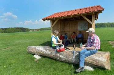
We follow the path to the crossroads at the edge of the forest. Here we turn left onto the Iggenhauser Weg. It joins the Grundsteinheimer Weg, which we follow to the right. We pass a white cross and have now reached the 324-metre-high Knipsberg. Here, at the highest point of our hike, there is almost always a fresh breeze. As we continue, we enjoy the wonderful view over the Paderborn plateau to the Hellweg to the west and the Sauerland to the southwest. There are information boards along the way about the Paderborn plateau and the use of wind energy. At the fork, we leave the asphalted Grundsteinheimer Weg to the left. There is a hut and picnic area right next to the model airfield where you can take a break. To the right of the hut is a board with information about sinkholes. We reach the perspective shown there around 300 meters further on, just before the small depression.
Stage 3: Knipsberg - Dahl [5.4 km]
We continue along the model airfield and follow the bend to the right, so do not head towards the wind turbine. Shortly before the small dip, we recognize a group of trees in the field on the left. These are two sinkholes, one behind the other. To the right of this, a little further on, we see another rather conspicuous group of trees. This is also a sinkhole, namely "Spielmanns Kuhle", the largest in this area. It has a depth of around 15 meters and a diameter of around 40 meters.
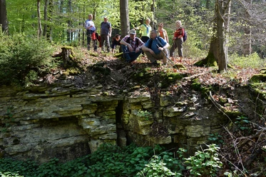
At the end of the path, we turn left. At the signpost in the hollow, we turn left and walk slightly downhill in the Merschetal valley. In the right-hand bend of our path, we see an information board about the Merschetal valley. We now climb around 50 meters in altitude over the next 600 meters. It's hard to imagine that there was a dense spruce forest here until 2021. At the top of the T-junction, we keep left and follow the forest path downhill. A good 100 meters before the valley floor, a gravel path joins from the right. To the left is a former quarry, which is difficult to see from the path in summer due to the overgrowth. Continue straight ahead, follow the bend to the right at the bottom of the valley and continue downhill. In this way, we have made a detour around the Merschetal wilderness area, which should not be entered.
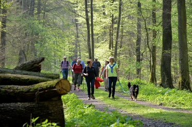
At the end of the forest, we pass a red and white barrier and about 100 meters later we have asphalt under our feet again. Immediately before the cycle path, we take a sharp left onto the gravel path. We follow this for about 15 minutes along the edge of the forest and enjoy beautiful views of the Ellerbach valley. At a transmission mast, we reach an asphalt road, the Grundsteinheimer Weg, which brings us back to our starting point, the multi-purpose hall.
Tour information
Familiy-Friendly
Loop Road
Equipment
Directions & Parking facilities
The city bus line 4 (PaderSprinter) runs between Paderborn and Dahl, the destination stops are "Dahl Post" and "Pastorskamp".
Further information on how to get there by city bus is available at www.padersprinter.de or by telephone on 05251 6997222.
Additional information
Königsplatz 10
33098 Paderborn
Tel. 05251 8812980
E-mail: tourist-info@paderborn.de
Internet: www.paderborn.de
Documents
Literature
Pocket book "The most beautiful half-day hikes in the Paderborn region and Eggegebirge" with 20 interesting circular tours through the local region (220 pages). Available at a price of 12.95 euros from Paderborn Tourist Information, bookshops (ISBN: 978-3-9809507-8-7) and - free of shipping costs - from HEFT-Zeitschriftenverlag (Tel. 05251 62624).
License (master data)

Author´s Tip / Recommendation of the author
An addition to the Paderborn Karst Trail is the Dahler Aussichtstour, which stretches north of the village. It offers wonderful views and introduces you to other karst phenomena. These include the Braunsohle - a water-filled sinkhole - and the calcareous grasslands in the Pamelsche Grund nature reserve.
The Way of St. James also runs along a section of the Karst Trail. The characteristic yellow scallop shell marks the hiking trail, which has been marked since 2010 and follows in the footsteps of the pilgrims from Höxter via Paderborn and Soest to Dortmund. The most scenic section is undoubtedly the 65-kilometre stretch from Höxter via Brakel and Bad Driburg to Paderborn, which can easily be divided into three one-day stages.
Further information: www.lwl.org/LWL/Kultur/jakobspilger
Safety guidelines
The tour runs across the Paderborn plateau, which can sometimes be very sunny and sometimes very windy. Therefore, make sure you have adequate protection from the sun and wind.
Social Media
Download GPX file
Photo Gallery


