Hermannshöhen - Etappe 07 von Bielefeld nach Oerlinghausen


- 3:15 h
- 14.78 km
- 294 m
- 213 m
- 161 m
- 295 m
- 134 m
- Start: Sparrenburg Bielefeld
- Destination: Oerlinghausen, town center
Please note: Lämershagener Straße (A2 bridge) is closed until the beginning of September due to renovation work - the detour is not yet marked. → Info & map here: Hermannsweg route reports
The stage at a glance:
1ststart and finish point of the stage
The stage begins at Sparrenburg Castle in Bielefeld and ends in the town of Oerlinghausen.
2.length of the stage in kilometers / altitude / route character
The stage runs for around 15 kilometers and has an altitude difference of around 300 meters. The route offers moderate ascents and descents.
3.special landscape features
The stage leads mainly through wooded areas, which offer pleasant shade on warm summer days. From the Bielefeld promenade, you have sweeping views over the city. Did you know? The first section of the Kammweg from Sparrenburg Castle is called "Promenade".
Highlights on the route
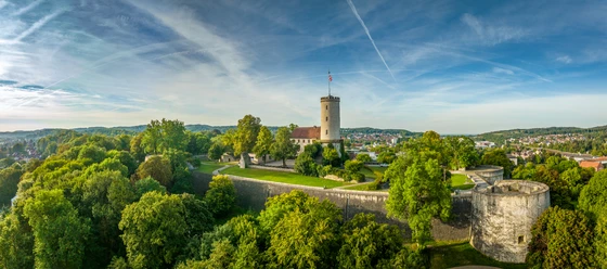
Sparrenburg Castle in Bielefeld is an imposing castle complex dating back to the 13th century. It is enthroned on a hill above the old town. The castle is Bielefeld's landmark and one of the most popular excursion destinations in the region. It is worth visiting the information center at the castle and the Anna & Hermann listening station just outside the castle grounds on the promenade.
The "Iron Anton" is one of the few metal Bismarck towers, built in 1895 and faithfully restored in 2003. The observation tower is located to the east of Bielefeld on the Ebberg on the Hermannsweg and offers a view to the north and south over the Teutoburg Forest.
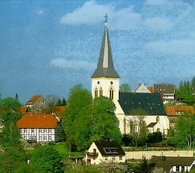
The Romanesque Alexanderkirche in Oerlinghausen is a church worth seeing in the heart of the old town. The organ with its carved organ case from 1688, the colorful stained glass windows in the choir and the oldest bell in the parish from 1547 deserve special attention.


Waypoints


Good to know
Pavements
- Unknown (2%)Street (2%)Asphalt (2%)Gravel (51%)Trail (30%)Path (13%)
Best to visit
- suitableDepends on weather
Directions
- On this stage you will find the following quality establishment of the Hermannshöhen:
Oerlinghausen:
Hotel Mügge am Iberg, Tel. 05202 91460
www.hotel-muegge.de Tour information
Familiy-Friendly
Possibility of Accommodation
Premium Trail "Wanderbares Deutschland"
Stop at an Inn
Tour with Dog
Equipment
- Sturdy shoes, binoculars.
Directions & Parking facilities
- Getting thereA2, exit Bielefeld Zentrum.ParkingThe cheapest parking garage is the Tiefgarage Altstadt-Carree, in the district below Sparrenburg
Parking spaces at the starting location:
Parking lot Sparrenburg (chargeable)
Am Sparrenberg 38, 33602 BielefeldBelow the castle
Bus/tramAdenauerplatz or LandgerichtTramp line 2 Altenhagen -BI-Hbf - SiekerTramp line 1 Senne- Bi Hbf - Schildesche
Fahrplanauskunft
Parking lot Schöne AussichtSchubertstraße 9, 33604 Bielefeld
direkt am WegBus stop August-Bebel-Straße
Stadtbahn 2 Altenhagen - BI-HBF - SiekerParking spaces with local transport connections along the route:
Parking space Eiserner Anton
Osningstraße 281, 33605 Bielefelddirekt am Weg
Keinanschluss an den Nahverkehrs!!!
Wanderparkplatz HabichtshöheBodelschwinghstraße 79, 33604 Bielefeld
direkt am WegBus stopHabichtshöhe
36 BI-Senne - Habichtshöhe - BI-Sieker (Stadtbahn)
Wanderparkplatz EisgrundLämershagener Str. 201, 33699 Bielefeld
539 m to the pathBus stopEisgrund or Wrachtrup
30 BI-Heidebl -Stieghorst-Zentr. (Stadtbahn)-Brake
Parking lot Marktplatz OerlinghausenMarktstraße 16, 33813 Oerlinghausen
approx. 350 m to the routeBus stopMarktplatz
39 BI-Sennestadt - BHF Oerlinghausen38 Oerlinghausen - Stieghorst Zentrum (Stadtbahn)
Public transportationYou can find detailed information for your journey by public transport here.
The smart number for bus and train in NRW:
Electronic timetable information: 08006 - 50 40 30 (free of charge)
OWL Verkehr GmbH: 05231/977 681
Bus timetable information online: westfalentarif.de Additional information
License (master data)

Author´s Tip / Recommendation of the author
- In Oerlinghausen, you can also take to the skies after your hike - Europe's largest gliding airfield beckons on the southern slopes of the Teutoburg Forest.
Our recommendations



Photo Gallery


