Wasserroute Paderborn/Delbrück


- 1:15 h
- 18.03 km
- 13 m
- 13 m
- 89 m
- 99 m
- 10 m
- Start: Paderborn-Sande, village square
- Destination: Paderborn-Sande, village square
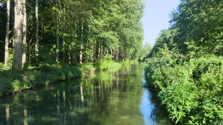
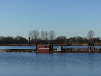
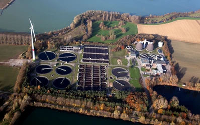
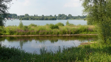
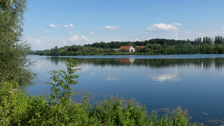
As the name suggests, this 18-kilometre, gradient-free water route is all about cool water in different contexts. The "water stations" are the Lippesee lake, the Boker-Heide canal, the Rothebach aqueduct, the Boker Heide waterworks, the quarry ponds near Bentfeld as well as the Paderborn sewage treatment plant and the Lippe, North Rhine-Westphalia's longest river.
The route runs mainly on asphalted field paths through the flat terrain between Paderborn-Sande and Delbrück.


Waypoints
Good to know
Pavements
Best to visit
Directions
Way description (anticlockwise):
From the starting point, continue along the asphalt road across the village square. Pass the red and white barrier at the end of the square. Follow the left-hand bend and cycle to Sennelagerstraße. Turn right. Shortly after the "Lippesee" bus stop, turn left into Am Kanal, which is closed to motor vehicles. Keep straight on at the crossroads. Cross the bridge (with blue railings) over the Boker Canal. After the left-hand bend, cycle along the canal
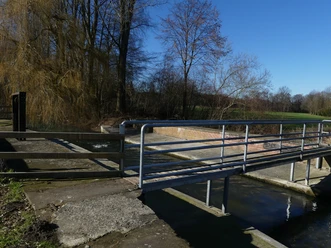
.At the end, turn left (Sander-Bruch-Straße) and immediately right again onto the footpath and cycle path alongside the canal. At Klausheider Straße, change sides of the canal and turn right onto Georg-Lucas-Weg. Change sides at the Pferdekamp / Vogelweide junction. Immediately before Ostenländer Straße (L 813), cross the canal again and continue along the canal on the left-hand side. After about 400 meters you reach a narrow iron bridge over the Boker Canal. It is part of the Rothebach aqueduct on which the canal crosses the small stream.
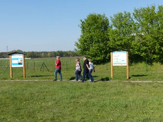
After around three kilometers, cross the B 64 (be careful here!) and head straight ahead onto the canal path. After about 300 meters, turn left (still on the canal path). Keep straight on at the mouth of Rasenweg and turn right into Doppheideweg after about 300 meters. Keep straight on at the next junction (Waldweg). Cross the L 815 in a straight line. At the end of the path, turn right. After a few meters, you will reach the Boker Heide waterworks and are almost halfway there.Now head towards the church in Anreppen. Cycle to the end of the path (Im Dorfe). Continue along Anreppener Straße to the left. At the junction with Paradiesstraße (junction to Boke and Lippstadt), keep straight on (Bentfelder Straße). Change to the cycle path at the town exit sign. Pass the Lippe bridge.Immediately after the bridge, the road "Am Römerlager" branches off. Here you can take a detour to the Anreppen Roman camp, which is just over 300 meters away.Follow the cycle path along Bentfelder Straße until shortly after the "Brinkmann" bus stop, Schafbreite branches off to the left. Cycle on this cycle and footpath, which is only around two meters wide, along a quarry pond in the direction of Bentfeld. In Bentfeld, cycle past the cemetery. Keep right at the crossroads at the end of Schafbreite. After almost 200 meters, at a wayside shrine, turn left into Berghöfen. Cycle past the kindergarten and playground to the church. Turn left there. At the traffic circle, take the second exit. After the right-hand bend, turn left into Mühlenweg - direction: sports hall. At the T-junction, after around 700 meters, turn left into Gesselner Straße. Follow this road - later called Mühlengrund - through a few bends until you reach a junction with Sandhöfener Straße, where you turn left. After about 700 meters, Bentfelder Straße branches off to the left before a right-hand bend. From here it is just under 200 meters to the entrance to the sewage treatment plant. The buildings and, above all, the two 40-metre-high digestion towers can already be seen at the junction.Continue along Sandhöfener Straße until you reach the K 28 (Am Brockhof). Cross this and continue left on the cycle path along the K 28. Shortly before the B 64, take a sharp left, cross the road Am Brockhof again and cycle into the field path opposite. Cycle under the B 64, then cross the Lippe on the pedestrian and cycle bridge and cycle along the unpaved path along the banks of the Lippesee to the Sande village square.
Tour information
Familiy-Friendly
Loop Road
Stop at an Inn
Directions & Parking facilities
By car:
Take the A 33 freeway to the Paderborn-Schloß Neuhaus exit; then take the B 64 towards Delbrück. After the Lippe bridge, turn right into Sennelagerstraße and follow this road for about one kilometer until you reach the Sande sports hall. Turn right here into "Zum Dorfplatz"
By bike:
Cycle from Paderborn city center on the Paderborn cycle tour 4 ("PB-Tour" 4) via Schloß Neuhaus to the village square in Paderborn-Sande.
Detailed information on how to get there by city bus is available at www.padersprinter.de or by telephone on 05251 6997222.
.
Additional information
Königsplatz 10
33098 Paderborn
Tel. 05251 8812980
www.paderborn.de
www.facebook.com/paderborn.tourismus
www.instagram.com/paderborn_tourismus
Documents
License (master data)
Karl Heinz Schäfer

Author´s Tip / Recommendation of the author
Safety guidelines
Social Media
Download GPX file
Photo Gallery


