Freizeit-Radroute "Engelroute"


- 4:30 h
- 47.27 km
- 253 m
- 253 m
- 72 m
- 157 m
- 85 m
- Start: Junction 13 (junction Am Brodhagen/ Grünzug Schloßhofbach) in the district of Schildesche
- Destination: Junction 13 (junction Am Brodhagen/ Grünzug Schloßhofbach) in the district of Schildesche
The Engelroute takes you to more than 20 of these farms, mainly through green spaces and along roads with few cars. Numerous refreshment stops and playgrounds along the route invite you to take a break. Nature lovers and recreation seekers will find nature reserves and extensive green areas to their liking. As the farms are privately owned, we ask you to respect the private area.
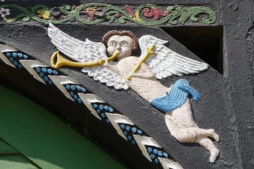
The angels: The entrance to many Ravensberg farmhouses is richly decorated with carvings. On the posts to the right and left of the wide gate, vines climb up from jugs, surrounded by birds pecking at the grapes - and angels hover above. Johan Friedrich Welhöner and his wife Anna Maria Ilsabein Papenbrock were probably the first to decorate the archway of their new farmhouse in Theesen with angels in 1789. This archway can be found today in the Auferstehungskirche Theesen.
(!) Detour to Hof Meyer zur Müdehorst (2x 1.3km):
From 1811 to 1813, the border between France (to the north) and the Kingdom of Westphalia (to the south) ran through the Schwarzbachtal valley. The wooden sign on the bridge over the stream with signs to Paris and Kassel is a reminder of this. The Meyer zur Müdehorst farm lies to the north of the idyllic Schwarzbach valley. The spacious grounds reflect the rural prosperity of past centuries. The entrance to the main house, a mighty half-timbered building dating from 1791, is richly decorated with carvings.
The landscape: The gently undulating plain between the Teutoburg Forest and Wiehengebirge mountains is characterized by floodplains and farmland. The route leads through this hilly landscape past some beautiful farms into the Valley of the Asbeke and Kinzbeke, which is a nature reserve. In order to gain more grassland for grazing or haymaking, the landscape began to be transformed as early as 1600. The "Wiskenmaker" straightened the stream valleys, flattened the valley floor and moved the streams to the sides of the valleys. This led to the creation of the "Sieke", which still characterize the landscape today. They run like a network of lifelines through the open agricultural landscape.
The Bielefeld green corridors: Between the Bielefeld districts of Brake and Schildesche, the route leads into the Johannisbachaue, where a semi-wild herd of Heck cattle graze. The Obersee was created by damming the Johannisbach. Further along the route, the numerous parks in a row allow for an almost car-free ride through the city on the Teutoburg Forest.

Waypoints
Good to know
Pavements
Best to visit
Directions
You can shorten or extend your tour on the "Engelroute" cycle route along the way. This is because the route runs entirely within Bielefeld's junction network. Signposts at the cycle route intersections (the junctions) show you the way to the next town, a nearby attraction or the train station. Large signs along the route inform you about other leisure cycle routes.
Recreational cycle routes Bielefeld
Tour information
Loop Road
Stop at an Inn
Directions & Parking facilities
NAVIGATION ADDRESS ( Tourist Information )
Niederwall 23
33602 Bielefeld
Light rail lines 1, 2, 3 and 4; Rathaus stop
.Always know what's running: The smart number for buses and trains in NRW: 01806 504030
(20 cents/connection from landlines and a maximum of 60 cents/connection from mobile networks)
Additional information
The "Engelroute" leaflet is available free of charge from the Bielefeld Tourist Information Office, the district offices and the ADFC Bielefeld.
Recreational cycle routes Bielefeld
Literature
The "Engelroute" leaflet is available free of charge from the Bielefeld Tourist Information Office, the district offices and the ADFC Bielefeld.
License (master data)
Stadt Bielefeld, Amt für Verkehr

Author´s Tip / Recommendation of the author
Bültmannshof in Bielefeld-Schildesche, a restaurant with a large terrace by the park pond (link:) Bültmannshof
Meyer zur Müdehorst in Bielefeld-Dornberg, a farm café with an idyllic garden on the Schwarzbachtal (link:) Meyer zur Müdehorst
Hof Meyer-Arend in Herford, an organic farm with lunch and store café (link:) Hof Meyer-Arend
Angels on Ravensberg farmhouses (PDF downloads) https://www.lwl.org/voko-download/BilderNEU/422_002Angermann.pdf
Safety guidelines
Some routes lead over private roads. We thank the owners for their permission to use the paths.
(!) A note about the farms with angel archways: As the farms are privately owned, we ask you to respect private areas. You can see most of the angels very well from the road.
Map
The "Engelroute" leaflet is available free of charge from the Bielefeld Tourist Information Office, the district offices and the ADFC Bielefeld.
Download GPX file
Photo Gallery


