Weser-Bever-Höhenweg


- 8:00 h
- 32.08 km
- 728 m
- 726 m
- 94 m
- 363 m
- 269 m
- Start: Beverungen steamer landing stage (Weserstrasse)
- Destination: Beverungen steamer landing stage (Weserstrasse)
Stage 1: From the Weser valley via the Eisberg to Roggenthal (12.5 km)
The tour begins on the Weser in Beverungen. Near the school center, your gaze falls on the Kreuzbergkapelle, the last station of a Way of the Cross laid out in 1858/1859. It is enthroned on the Kapellenberg, which not only offers tranquillity but also a magnificent view of Beverungen and Lauenförde as well as the Weser Valley.
At the Wanderpilz, an ideal resting place, you can enjoy an excellent distant view: On the far left - between Galgenberg and Kapellenberg, so to speak, over which the granary emerges - the Weser peeps out, further to the right some gravel pits and, on the eastern and already Lower Saxony side of the Weser, large halls from the Lauenförde industrial estate.
From left to right, some striking buildings stand out from the seemingly homogeneous settlement body: the Catholic parish church of St.-Johannes-Baptist parish church from 1698 with its baroque spire, the retirement home (painted yellow), the former The former district court with its striking stepped gable and Beverungen Castle from 1330, then the pointed tower of the Protestant church built in 1866; at the same height, the Protestant St. Mark's Church from 1569 in Lauenförde, only offset to the rear, i.e. to the east, but already located on the Lower Saxony side of the Weser; a little further to the right, but again on the Westphalian side, the Beverungen town hall; and a little further to the right, the Weser breakthrough between Herstelle and Bad Karlshafen can be seen.
The following path then lets you enjoy the forest tranquillity of the iceberg. The Eisberg comprises around 420 hectares of forest. Its main feature is its nutrient-rich, shallow limestone soil and the resulting extreme lack of water due to its south-facing slope. The dryness naturally influences the growth height of this typical orchid-beech forest. At the same time, the numerous dry shell limestone hilltops form niche sites for around 20 rare deciduous trees, e.g. wild apple, wild pear, sessile oak, ash, hornbeam, bird cherry, elm, field elm, Norway maple and field maple, as well as wild service tree, which is one of the most valuable woods of all. Only around 1% of all forest sites in Germany have these niche forest communities.
After around 6 km - at the edge of the forest - you can enjoy an unobstructed view of Gut Oeserborn. Incidentally, the building on the left is the Bildungszentrum Beverungen der IG Metall on the Elisenhöhe near Drenke. This facility was founded in the early 1950s as the Elisenhöhe training and recreation center by the textile and clothing trade union. Since 1964, it has been known as the 'Werner-Bock-Schule' - named after the first chairman of this trade union - and since the integration of the GTB into IG Metall on 01.07.1998, it has been one of the seven central educational institutions of this trade union.
Soon Roggenthal is also reached. Formerly an agricultural estate with a mill that was already mentioned before the Thirty Years' War, a vacation village was built in 1982, which was mainly frequented by Dutch holidaymakers. For some years now, however, the former vacation homes have been used exclusively for private purposes.
Looking further south, you can already see the outskirts of Dalhausen with the house peeking out on the slope of the 328 m high Schnegelberg; even further south, on the other side of the valley, the 301 m high Kreihenberg. Immediately in front of you - across the main road 241, which follows the increasingly narrow Bever valley bordered by steep slopes - the Jakobsberg Forest rises up on the shell limestone massif up to 340 m high.
In Roggenthal you will now also come across the 13 km long "Kalkmagerrasen Dalhausen" high-altitude circular trail, whose route to Dalhausen is identical to the route of the Weser-Bever-Höhenweg.
Stage 2: From Roggenthal to Dalhausen (4.8 km)
First, the route now mainly leads through deciduous forest.
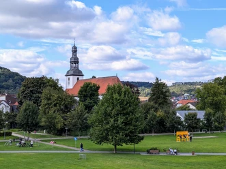
Then follow the wonderful grass path, which takes you about 1 km along the steep slope of the Schnegelberg: the grazing area for goats. It allows you to enjoy a magnificent view of Dalhausen . The settlement, which is over 1,000 years old, is literally enclosed by mountain ranges, interrupted only by several gorge-like side valleys that lead into the village located in the valley of the Bever .
This stream, which is around 10 km long, is formed around 1 km away from the confluence of the Jordan, Eselsbach and Lebersiek rivers. The erosive force of the Bever, which created this valley, becomes particularly clear when you look at the valley. The source of the Bever is around 181 m above sea level, its mouth into the Weser near Beverungen around 93 m above sea level.
The extremely narrow valley location and the poor soil conditions did not allow for significant economic development opportunities in Dalhausen: people used to live more poorly than well from agriculture, goat farming and basket weaving.
Until well into the 20th century, goats were part of everyday life in Dalhausen. They were kept as dairy goats, 'picked up' by a shepherd in the morning and returned to the village alone from the mountain slopes in the evening: no way 'stupid goats', every goat knew exactly which stable it belonged in. In the 1960s, up to 200 goats were still grazing on the mountain slopes.
The goat was considered the 'cow of the little man'. Keeping a cow was too expensive for many. Sheep were out of the question because they were not suitable for keeping indoors and also gave less milk. In short, there was no alternative to goats.
The Dalhauser Almabtrieb is a reminder of this time. For almost 20 years now, it has been held every year at the beginning of October - a fun spectacle that always delights spectators when the bleating four-legged animals are led through the village accompanied by a brass band.
The goats are also used for active nature conservation: in 2001, the 'Bergwiesen Dalhausen Producers' Association' was founded under the auspices of the Borgentreich Landscape Station, which is responsible for managing the calcareous grasslands in order to prevent the slopes from becoming overgrown with bushes with the help of the goats.
These shallow limestone soils are mainly characterized by a lack of nutrients and water, so that drought-loving plants are particularly prevalent. Despite the beautiful view, you should therefore also look out for small attractions at your feet: Because depending on the time of year, you will be able to enjoy the blue flowers of the Germangentian here, for example.
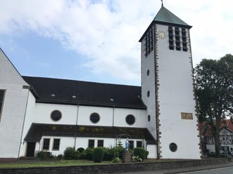
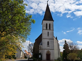
In Dalhausen itself, you should definitely take some time and leisure to visit the Catholic parish and pilgrimage church of the Nativity of the Virgin Mary. When you enter the church via the vestibule, you are sure to be "immediately struck by the well-proportioned, harmonious spatial design and its imprint with a world of images in which the formal design and content complement and merge with each other, thus accentuating the idea of this church, namely to be a place of deepest devotion to Mary. For just as numerous depictions of Mary adorn the altars, there are quite a few sculptures of precisely those saints whose lives and work were determined by an intimate relationship with the Mother of God." (Hermann-Josef Sander: St. Marien Dalhausen (Schnell & Steiner Kunstführer Nr. 2275), Regensburg 1996, p. 11)
Pay particular attention to the picture of grace on the southern side altar - an approximately 30 cm tall Gothic wooden sculpture from 1300 depicting the Virgin Mary with the infant Jesus - and on the northern side altar to the figure of "Mother Anne the Knight", an approximately 40 cm tall Gothic oak sculpture from 1510.
The miraculous image and the title of the church 'Nativity of Mary' were decisive factors in the creation of the pilgrimage, which is said to have been first carried out around 1403.
It is not only on the two traditional pilgrimage days of the 'Visitation of Mary' in July and the 'Nativity of Mary' in September that numerous pilgrims from near and far are drawn to the church, which was built in 1721, extended in 1950 and refurbished with its original baroque altars in 1985.
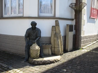
The Dalhausen Basketmaker Museum, which is located just a few hundred meters from the church, is also well worth a visit. The multifaceted history of the basket-making trade in Dalhausen is vividly documented and explained on an exhibition area of around 380 square meters using numerous original exhibits and comprehensive text and image information.
The focus is on the reality of human life, not on a detached aesthetic - and this is precisely where the appeal of this museum lies. With its 12 exhibition units - including an original basketmaker's hall, which brings to life numerous details of working habits and internal work organization - and the basketmaker's workshop, it is sure to delight every visitor.
However, thanks to regular temporary exhibitions, this museum not only presents craftsmanship, but also proves to be an ideal forum for reflecting on the significance of art and everyday culture.
Stage 3: From Dalhausen to Klus Eddessen (5.1 km)
After a climb of around 1 kilometer, you will reach the Mariengrotte.
Before the last steep section, the "Kalkmagerrasen Dalhausen" high-altitude circular trail branches off to the left and leads over the Kreihenberg and Jakobsberg to Roggenthal, where you first came across this trail.
The grotto then invites you to take a contemplative break. This Marian shrine was built in 1958 by a Dalhausen resident born in January 1927 in agreement with the then pastor of Dalhausen, Joseph Feldmann, out of gratitude for having survived the turmoil of war unscathed as a young man. Interesting to know: The grotto was built by a bricklayer from Borgholz, and it stands on the territory of the town of Borgentreich. But at the time, it was the beautiful location and not a municipal boundary that was decisive for the location.
A little later, at the edge of the forest, you can enjoy a view of a completely different landscape: Looking counterclockwise (i.e. from northwest to south), the top of a church spire appears above the forest adjoining the field in front of you, namely from the Catholic parish church of St. Marien (1834) in the village of Borgholz. Because of the forest, however, the former titular town, which Bishop Otto von Paderborn laid out according to plan in 1291 and surrounded with a town wall, is hidden from your view.
Slightly northwest of Borgholz, the domes of a biogas plant appear, behind which you can see the houses of Drankhausen.
The Bannenberg adjoins Drankhausen on the right. The horizon in the far west is bordered by the Eggegebirge mountains with its 133-metre-high transmission tower, which is followed to the south by the peaks of the Sauerland.
If you look further to the left - but more in the foreground and about 2 km from Borgholz - you will discover the small village of Natzungen with the massive Romanesque tower of the Catholic parish church of St. Nikolaus. Further to the left, over the hill with the spruce forest, Hohenwepel appears with its striking water tower, which catches the eye due to its unusual shape. An explanation for its apparent shapelessness, due to its tapering shape, can be given quickly: Especially on flat land, it is often difficult to provide the appropriate water pressure. This was remedied with these types of elevated water tanks, in which the lower part of the tower merely serves as a support system for the upper part, which is larger the greater the volume of the water tank it contains. And the larger the volume, the higher the water pressure.
Further to the left, but again more in the foreground, the 277 m high Spiegelsberg - a volcanic breakthrough - comes into view in the south, with two trees standing on its flattened summit.
Below this mountain (to the southwest), a busy ribbon of traffic shimmers: the federal highway 241. On the hill to the left of the Spiegelsberg, the rotor of the 50 m high wind turbine from the Elensburg farmstead turns.
In autumn you will certainly notice a column of smoke between the wooded area to the right of this wind turbine and the group of trees to the left of the Spiegelsberg: a striking reference to the sugar factory built in 1882, which is now one of the Südzucker AG plants, located on the outskirts of the former Hanseatic town of Warburg.
Your path now leads steadily downhill, and after a good 2 km you have reached the valley of the Lebersiek . About 2 km northwest of here, this small meandering stream joins Eselsbach and Jordan to form the well-known Bever, which you will encounter again later in Beverungen
At the edge of the forest, you will soon reach the grave of the Old Baron. Adolf Freiherr von Amelunxen (17.12.1866 - 25.09.1957), retired master forester, found his final resting place here with his wife Elisabeth, who died in 1958. He was regarded as a man "whose most striking characteristics were ruthless toughness towards himself and warm-heartedness towards all his fellow human beings. Spartan simplicity, uncompromising love of truth, with deep faith and fear of God, characterized his nature. He was always on duty throughout his life, his greatest happiness was the fulfillment of his duty. Nevertheless, his cheerful heart never let his sunny humor dry up." (Obituary on the death notice for Adolf Freiherr von Amelunxen, Druckerei Heinrich Werth, Warburg 1957) .
Your path will soon lead you to Klus Eddessen.
This chapel, which is known far beyond the region, was built at the end of the 15th/beginning of the 16th century in memory of the village of Eddessen, which was destroyed by Hussites in 1447 as part of the Soest Feud (1444 - 1449). Incidentally, the five-year conflict between the Archbishop of Cologne Dietrich II von Moers and the town of Soest is known as the Soest Feud. Although he used Bohemian mercenaries to enforce his interests, the town of Soest was ultimately able to assert itself.
The present-day Klus dates back to 1856. Interrupted by periods when it was unoccupied, numerous Klusners served here.
From 1860 until the beginning of the First World War, Brother Ubaldus worked here. His grave lies in front of the chapel, and even during his lifetime he used his self-made coffin as a place to sleep instead of a bed!
From 1970 to 1975, Brother Hermann, who became famous beyond Europe's borders, lived in a small wooden hut not far from the Klus and proclaimed a "life of worldwide simplicity". For several years, a hermit lived in the residential wing of the hermitage and took care of the preservation of this peaceful place.
In May and September, the people of Borgholz make pilgrimages to the hermitage on the ecclesiastical feasts of the Finding of the Cross and the Exaltation of the Cross - reminiscent of the vow made in 1676, when the Red Ruhr plagued Borgholz. The population from Dalhausen, but now from the entire pastoral area of Beverungen, always undertake a procession to the Klus on the second day of Pentecost.
Stage 4: From the Klus to Haarbrück (4.2 km)
You are here in this area, by the way on the so-called. Eiserweg, an ancient trade route that comes from the Waldeck area and continues via Marsberg, Rimbeck, Warburg, Borgentreich and Haarbrück to Beverungen. The name of this route is a reminder of the former iron trade, for which Beverungen was an important transshipment point. "About the Eiserweg it says in a Paderborn register: `A country road, which is used with bar iron, so from the Waldeckschen over the nearby stage situated wood, the Eichhagen, over Warburg, Borgentreich to Beverungen goes. But it is a bad way, especially because of the Haarbrück between Mühlenberg and Papenstieg, down to Beverungen.' In 1781, 50 wagons of pig iron are said to have been brought to Beverungen in just one day." (Pastor Basse: Haddenberg, the later Jakobsberg/Krs. Höxter,from: Dreizehnlinden - Heimatklänge aus dem Höxterland Nr.111/Jg. 11 vom 24.02.1934, S,. 465).
Shortly before entering Haarbrück, at the level of the fenced property on the left side of the path with trees and a hut, there is a really fantastic view. Let the landscape take effect on you! Explore some of the striking points in an anti-clockwise direction:
On the left, you will notice the Wartturm from 1429 - the ruins of a former land defense tower, which consisted of several ramparts and ditches overgrown with impenetrable thorny hedges to prevent enemies from entering. Many of the hills were topped with watch towers manned by lookouts. After the Thirty Years' War, these old defenses fell into disrepair. Walls and ditches were leveled because agriculture was hindered
To the left of the lookout tower - in the northwest - you will discover a striking round dome on the barren plateau of the Hegge: radar screens rotate beneath it. Until 1993, the bunker of the Auenhausen radar station located below was still used by a radar guidance unit of the German Armed Forces; today, however, the data is transmitted electronically to several more distant locations. Below the station, the houses of the small village of Auenhausen nestle in a small hollow.
Further to the left, you now have a wide view of the Warburger Börde: a typical agricultural landscape, and the view over the undulating hollow shows that arable farming dominates the land use. It accounts for over 85% of the Börde's agricultural land. The parent rock in the formation of the fertile Börde soil is loess, which was blown in during the last ice age and gives the Börde its typical yellow soil color. It is interesting to know that the main farms in the Börde cultivate an average of around 50 - 150 hectares of agricultural land.
Your view of the Börde is limited by the "blue walled wall of the Egge, towering like an alp" (Jürgen von der Wense: Wanderjahre, Matthes & Seitz edition, Berlin 2006, p. 289) - the dominant ridge in eastern Westphalia. The north-south facing mountain range (highest elevation: Velmerstot at 468 m) connects the Teutoburg Forest with the Sauerland. The 133 m high transmission tower near Willebadessen towers above the horizon line in the west.
The Eggegebirge forms the watershed between the Rhine and Weser. Its enormous damming effect is particularly significant with regard to the distribution of precipitation. Up to 500 mm more precipitation falls in the Egge than to the west and east of it.
Then to the southwest is the Desenberg . It is part of a chain of volcanic phenomena that extend from the Hessian depression to here in Westphalia. At 345 m, it towers above the flat surrounding countryside as the only elevation - a former robber baron's castle from 1300 is enthroned on its summit - so that this "monarch and center like a pyramid" (Jürgen von der Wense, p. 452) is not wrongly referred to as the landmark of the Warburger Börde.
With an altitude of 365.1 m, Haarbrück is the highest place in the urban area of Beverungen and in the district of Höxter in general. In the past, this exposed location was of strategic importance, as the settlement, which was probably founded around 1200, formed a natural bridge between the Warburger Börde and the Weser valley near Herstelle and Beverungen. If you think about the mostly adventurous road conditions of earlier times, it was almost only possible to get through on paths via the heights, in contrast to the often swampy lowlands.
At the rest bench in front of the transmitter mast, you will once again find an excellent vantage point:
From left to right, i.e. clockwise, you can see the heights of the Sauerland, the expanse of the Warburg Börde in front of it, the Egge with the transmitter tower behind it and the crater-like basin of Dalhausen in front of you. However, due to the plateau character of your location and the deep valley incision, you can only see the houses on Schnegelberg, along the slope of which you previously hiked. In front of you is Jakobsberg, behind the wind turbines to the north-east is Köterberg, followed by the steep slopes of Brunsberg and Ziegenberg near Höxter, the widening Weser valley near Holzminden with its reservoir located directly on the Weser and, on the slope of Kathagenberg, the tower of the Protestant Christuskirche church in Fürstenberg.
You will soon reach the Kornhaus.
Stage 5: From Haarbrück to Beverungen (6.6 km)
Around 900 m from the Kornhaus, on the hill, you can again enjoy an incomparable distant view:
If you look back south along your route, you will discover the transmission mast on the 392 m high Heuberg near Hofgeismar, approx. 14 km from your location, even further south the 186 m high Fernmeldeturm Habichtswald on the 595 m high Essigberg near Kassel, about 35 km away from you.
On the left of this line of sight in the foreground is the 389 m high Deiselberg, further left, above the Diemel valley, the 13th century Trendelburg with its massive keep.
If you look further to the left, towards the south-east, you will see the village of Friedrichsfeld, situated on a plateau on the edge of the Reinhardswald forest.
With Solling and Bramwald - both on the eastern bank of the Weser - the Reinhardswald is one of the largest contiguous forest areas in Germany. At around 210 square kilometers, it stretches from Hann. Münden to Bad Karlshafen and is around 35 km long and up to 15 km wide. Its extensive plateaus rise up to around 400 m above sea level. In addition to beech trees, there are also large, closed stands of oak, which is rather rare in Germany. It is rightly regarded as a fairytale forest in a legendary landscape, where the Brothers Grimm collected their folk tales at the beginning of the 19th century.
Diagonally to the left, but more in the background, is the Sababurg, located in the heart of the Reinhardswald, so to speak. In the Middle Ages, it was known as Zapfenburg, which the Bishop of Mainz had built in 1334 to protect the numerous pilgrims who made the pilgrimage to Gottsbüren. Word of the miracle of Gottsbüren had spread, according to which bleeding hosts had been found here and even the 'Savior of the World', a young man who bore the features of Christ and his stigmata, which later developed into a Holy Blood pilgrimage (The spiritual background to this pilgrimage and its time can be found in Hermann Multhaupt: Das Wunder vom Reinhardswald - Roman aus dem Mittelalter, Paderborn 2007).
You can discover the tower of the former Gottsbüren pilgrimage church, located in a hollow, if you look a little further to the left.
Further to the left, but more in the foreground, is the Solling; it adjoins the Reinhardswald to the north, overlooked by the 159 m high Solling telecommunications tower of Deutsche Telekom, near Espol near Hardegsen.
A little further to the left is the massive Solling Tower on the 444 m high Strutberg northwest of Uslar, clearly recognizable by its shimmering green copper dome.
Further to the left on the horizon is the Hexter telecommunications tower on the 452-metre-high Hasselberg near Neuhaus in Solling.
In front of you is the white Fürstenberg Castle with its world-famous porcelain manufactory and Holzminden with its granary deep in the Weser valley.
To the north-east of Holzminden, bordering the horizon, a large building, the former Ith civilian service school, on the slope of the rocky mountain range of the same name, which is up to 439 m high and is well known not only to crossword puzzle fans but also to climbers.
To the north are the wind turbines on the Bosseborner Höhe, further north again the Köterberg and to the west again the transmission tower on the Eggegebirge.
From your location, you will inevitably notice a wind power giant that was erected in 1999 with a height of 97 m up to the hub height and a rotor of 66 m, which was the largest turbine in NRW at the time.
But now be sure to take a look to the right between the wind turbine and the power line pylons. On the horizon - almost 100 km away from you as the crow flies! - the massif of the 1142 m high Brockenin the Harz! An excellent, i.e. very clear view is of course a prerequisite.
From the large fork in the Schifftal valley, it is still about 3.9 km to the steamer landing stage in Beverungen. Above the Weser valley, the view of the former Würgassen nuclear power plant, the Weser and the B 83 federal road is then clear.
This 650-megawatt plant has been supplying electricity since the end of 1971 and was the largest boiling water reactor in Europe for many years.After cracks were discovered in the core shell during an inspection, the power plant was taken off the grid in August 1994. Although it was initially assumed that the reactor could be restarted, the operating company, PreussenElektra in Hanover, decided on June 1, 1995 to shut down the Würgassen NPP for economic reasons. The basic refurbishment of the power plant, including the replacement of the core shell, would have cost around €100 million up to the time of recommissioning alone, and expenses of this amount would have been incurred again at a later date. The dismantling of the power plant was then completed in August 2014
Overlooking the power plant, you can see the mighty rocky cliffs of the 291-metre-high Rotsberg with its radio transmitter, at the foot of which the B 83 federal road leading from Bebra to Bückeburg passes - the so-called Bremer Straße, an old trade route high on the left bank of the Weser.
About 300 m further on, the horizon straight ahead is bordered by Reinhardswald and Solling, to the south by the monastery and castle Herstelle, below Herstelle with the Catholic parish church of St. Bartholomew from 1710. Immediately in front of you across the Weser is the Axelsee lake and the Dreiländereck marina, the only natural harbor for pleasure boats on the Upper Weser, with Lauenförde and the gently rising Solling to the left.
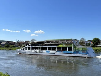
The Bootshaus Beverungen is run by the Beverungen water sports club. Founded in 1950 as a pure canoeing club, the WSV is now the largest sports club in the town of Beverungen with more than 900 members and one of the largest popular sports clubs in the local border triangle. With a public restaurant, meeting rooms and overnight accommodation, an adjoining campsite and permanent pitches for caravans, the boathouse is an important port of call for rowers and canoeists. Its importance is also reflected in the fact that it has established itself as a recognized training centre of the administrative district of Detmold for teacher training in canoeing.
700 m from the boathouse, you will reach the Bever Meander - an ideal opportunity to visualize the interplay of erosion and landing by the force of the water. From here, it is around 850 m until you reach the starting point of your hike at the steamer jetty .

Waypoints
Good to know
Pavements
Best to visit
Directions
Start your tour at Mers-les-Bains-Platz on the Weser in Beverungen. First follow Weserstraße until you reach Lange Straße, where you turn right. After just a few steps, cross the road at the traffic lights and turn left into Zum Stadtgraben. Cross Untere Nußbreite to reach Obere Nußbreite, which takes you to Lindenstraße, which you follow straight ahead.
You then cross the former level crossing of the former Beverungen-Lindenstraße train stop.
Then turn left into the street Unterm Eisberg and a little later into the street Zum Sonnenhügel. The route now climbs gradually for around 900 m, and as you look back, your field of vision widens more and more towards the Weser valley and the Solling, which borders the horizon, as well as Galgenberg and Kapellenberg.
Keep to the left and after a steep section of around 200 m, you will reach the Hiking Mushroom on the slope of the iceberg, which offers an ideal resting place and at the foot of which you can enjoy an excellent distant view.
You now follow the slightly ascending asphalt path and after about 400 m, in the bend to the right, straight ahead on a path that lets you enjoy the forest silence of the iceberg.
The path now goes slightly uphill and then downhill, and after around 2.4 km you reach a fork in the path: turn right uphill and keep left.
After another 2.3 km, you reach another wide fork in the path. Now keep left - the path now descends moderately steeply - and after around 400 m, the view opens up to the right: Gut Oeserborn can be seen peeking out from behind the two trees, above - in summer - rolling fields of grain. After another 300 m, follow the asphalt path to the left. Another 600 m, then turn right onto the gravel farm track. It's quite a steep climb now, but just be inspired by the expectation that your efforts will be rewarded with another magnificent view of Gut Oeserborn and the WBS training center as soon as you reach the edge of the forest after around 600 m .
Continue along the edge of the forest for a little while, then take the farm track to the left: initially through spruce forest, then mainly through deciduous forest. After around 900 m, you will see the Bever valley on your left. At the large fork, which you reach after around 600 m, take the path to the left and the route now descends moderately steeply for around 1 km.
Take a short break under the mighty oak tree at the edge of the forest: To the right, your gaze falls on Roggenthal.
You now stay on the path until you reach the country road, which you cross here and follow to the right for 200 m (take care!) before turning left into the road 'Unterm Hübbeln'
.Stage 2: From Roggenthal to Dalhausen (4.8 km)
After around 250 m, turn right into the forest. The first hill is reached after another 150 m. Now enjoy the charming forest path, which winds in several turns above the Bever valley. After 1100 m, you will come to the wide farm track in Hasselntal, which you follow to the left.
The path climbs slightly up to the sharp left-hand bend, which you reach after 300 m. Your view then opens up to the left and falls across the valley to Jakobsberg.
After another 1.1 km, take a short break and enjoy the view (from left to right) of the Bevertal valley near Roggenthal, Jakobsberg and Haarbrück.
A little later, Dalhausen lies ahead of you. Turn right, follow the steep path for about 100 m, then turn left onto the beautiful grassy path, which leads you along the slope of the Schnegelberg for about 1 km.
For about 200 m, the path then descends steeply to the mountain road and continues to Hellwegstraße, which you follow to the left, and after 400 m you reach Untere Hauptstraße.
Follow the main road to the right and after 150 m you will reach the Catholic parish andParish Church of the Nativity of the Virgin Mary.
From St. Mary's Church - after a few steps - continue straight ahead across the Bever
.Before continuing straight ahead towards the railroad overpass, you should first turn right into Lange Reihe to visit the Korbmacher-Museum, which is only around 100 m away.
After the detour to the museum, head back to the railroad bridge of the disused Scherfede - Holzminden line. Turn right into Zum Eichhagen and then left after around 120 m.
Stage 3: From Dalhausen to Klus Eddessen (5.1 km)
Up to the grotto, you have a climb of around 1 km ahead of you
Before the last steep section, the "Kalkmagerrasen Dalhausen" high-altitude circular trail branches off to the left and leads over the Kreihenberg and Jakobsberg to Roggenthal, where you first came across this trail.
After a rest at the Mariengrotte, continue straight ahead on the path, which climbs a little again, and after around 100 m you have finally reached the hill and have arrived at the edge of the forest. Your field of vision opens up, but follow the path for another 100 m or so to the fork in the path and enjoy the view across the fields, which now presents you with a completely different landscape.
You then follow the path to the left into the forest and after another 400 m you reach a fork, which you go straight on past. It will certainly be easy for you to forge ahead again now that your path is always downhill.
After around 1.5 km, you have reached the Lebersiek valley.
Keep left initially and turn left again about 20 m after the road barrier onto a grassy path that takes you back over the Lebersiek
.
After a short but steep climb, you will soon reach the grave of the Old Baron.
A little later, the grass path meets the paved farm track. Follow this path, which runs between woods and fields, for about 500 m and then straight ahead for another 500 m along the now narrower forest path, which leads you to Klus Eddessen.
Stage 4: From the Klus to Haarbrück (4.2 km)
With the Klus behind you, take the third path from the left. The path climbs very gently and as soon as you reach the top, turn right.
After around 500 m, you will reach the edge of the forest and after another 200 m the asphalt farm track. Here your field of vision opens up to the south and south-east, giving you a view of Hesse's volcanic mountains. Continue straight ahead for about 300 m, then turn left and after another 350 m turn right. Continue straight ahead for around 750 m: your field of vision widens with every step, allowing you to experience more and more of the magnificent panoramic view.
250 m further on, you will reach the outskirts of Haarbrück, the highest village in the Beverungen municipal area and in the district of Höxter in general.Stay on Holzbrunnenstraße, keep left at the wooden cross under the lime tree and after another 100 m turn right at the fork into Höhenweg. 100 m further on, immediately at the rest bench, turn left and after another 100 m you will be presented with another magnificent panorama.
Follow the path for another 150 m until you reach the bench on the right
At the next fork in the path, keep right and after 250 m you have reached Klingelburgstraße, which you follow to the left for just under 100 m until you reach the Kornhaus.
Stage 5: From Haarbrück to Beverungen (6.6 km)
Immediately after the Kornhaus, turn right onto the asphalt farm track. Follow this for around 350 m to the next fork in the road; turn left there and then left again after a few steps. The path now climbs a little again, but your field of vision widens with every step.
Once you have reached the hill after around 500 m, 40 m before you reach the asphalt farm track, you can enjoy an incomparable view as far as the Brocken in the Harz mountainsTurn left onto the paved farm track, which you follow straight ahead
A few steps before the country road, turn half right and then follow the narrow grass path a few steps behind the field cross, which will lead you downhill into the Schifftal valley. As soon as you reach the wide fork, keep left and then take the path on the right uphill. It is now about 3.9 km to the steamer landing stage in Beverungen, and the forest path ahead of you leads you in several loops above the Weser valley to Beverungen and repeatedly opens up the view to the right: for the first time after about 600 m, you will see the Weser valley and the Würgassen nuclear power plant, after another 300 m you will see the power plant again as well as the Weser and the B 83.
300 m further on, you should enjoy the view again
After another 200 m, turn right. It is a moderately steep descent, and after around 700 m you have reached the B 83 main road
Follow this road to the left for 200 m (take care!), then cross it to the right and after 250 m you will have reached the Bootshaus Beverungen.
Now continue along the Weser cycle path, which will take you to the Kneipp treading pool and the Bever meander after around 700 m. From here, it is around 850 m until you reach the starting point of your hike, the Mers-les-Bains square at the steamer jetty.
Source information
Jean-Jacques Rousseau, quoted from Ulrich Gruber: Vom Wandern - Neue Wege zu einer alten Kunst, Reinbek bei Hamburg 2011, p. 246
Uwe A. Oster (ed.): Rivers in Germany - A Cultural History, Darmstadt 2007, p. 19 - 34
Route description "Wo der Bock zum Gärtner wird - Kalkmagerrasen bei Dalhausen", published by the District Administrator of Höxter, n.d., n.d.
Horst-D. Krus: Flüsse - Bäche - Auen im Kulturland Kreis Höxter, published by the District Administrator of the District of Höxter, Höxter 2007, p. 122 - 130
Ernst Kloepfer: Die Ernährung und Haltung der Ziege als Milchtier des kleinen Mannes, Essen 1896; quoted from: Gisbert Strotdrees: Der Doktor und die Ziegen, in: Landwirtschaftliches Wochenblatt Westfalen-Lippe Nr. 27 (07.07.2011), p. 95
Eckhard Fuhr: The goats win, in: Welt am Sonntag No. 44, 30.10.2011, p. 16
Hermann-Josef Sander: St. Marien Dalhausen (Schnell & Steiner Art Guide No. 2275) , Regensburg 1996 , p. 11
Evelyne Polt-Heinzl and Christine Schmidjell (ed.): Kleine Weisheiten für Wandervögel, Stuttgart 2006, p. 78
Martina Abel: Too much bioenergy?, in: Landwirtschaftliches Wochenblatt Westfalen-Lippe No. 37, 15.09.2011, p. 33
German Dictionary (electronic edition of the first edition by Jacob and Wilhelm Grimm, published by the Competence Center for Electronic Indexing and Publication Procedures in the Humanities at the University of Trier in conjunction with the Berlin-Brandenburg Academy of Sciences and Humanities, Frankfurt/M. 20065, vol. 12, p. 872/78 and vol. 16, p. 951/58
Sheets of the Royal Prussian map survey 1 : 25,000 from 1838
Obituary on the death notice for Adolf Freiherr von Amelunxen, Heinrich Werth printing works, Warburg 1957
Festival committee "1000 years of Manrode" (ed.): Ananroth 1009 - Manrode 2009 - 1000-year history of a village, Borgentreich n.d.
Pastor Basse: Haddenberg, the later Jakobsberg/Krs. Höxter, from Dreizehnlinden - Heimatklänge aus dem Höxterland No. 111 (Vol. 11) from 24.02.1934, p. 465
The curse of Midas, in: F.A.Z., 10.01.2008, p.14
Jürgen von der Wense, Wanderjahre (Edition Matthes & Seitz), Berlin 2006, p.289, p. 305 and p. 452
Information on the Internet at: h ttp://www.bezreg-detmold.nrw.de/400_WirUeberUns/010_Pressearchiv/2010/032010/025_10/index.php; retrieved on 28.11.2011
Hermann Hartmann: Village mosaic Haarbrück - Stories and incidents from the 750-year history of a village, Borgentreich 1999, p. 72 - 74
Tour information
Multiday Tour
Equipment
- Sturdy shoes
- Binoculars
Directions & Parking facilities
- via the B 241 from the direction of Warburg and Uslar
- via the B 83 from Höxter and Bad Karlshafen
- Bus route R36 Borgentreich - Lauenförde
- Bus route R37 Fahrradbus Wisent-Linie Scherfede - Bad Karlshafen
- Bus route 524 Dalhausen - Haarbrück/ Borgholz
- Bus route 533 Dalhausen - Bühne
- Bus route 560 Borgentreich- Bad Karlshafen
Additional information
Service Center / Weserstraße 16
37688 Beverungen
Contact person
License (master data)
Tourist-Information Beverungen

Photo Gallery


