Von den Paderquellen zum Lippesee


")
- 2:30 h
- 10.34 km
- 3 m
- 19 m
- 94 m
- 113 m
- 19 m
- Start: Abdinghof Church Paderborn
- Destination: Church in Paderborn-Sande
This leisurely hike first runs along the Pader from its sources in Paderborn city center to the confluence of the Pader and Lippe rivers in Schloss Neuhaus. It then leads through Neuhaus Castle Park and along the Boker Canal to the Lippesee lake, then along the northern shore of the lake to the church in Sande.
Waypoints
Good to know
Pavements
Best to visit
Directions
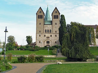
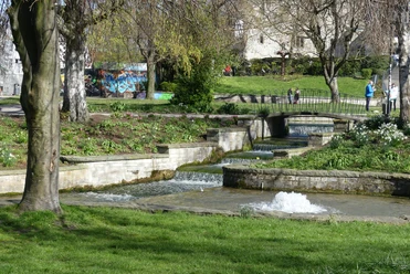
The starting point of the hike is the Abdinghof church. We descend the stairs into the western Pader spring area and walk through the listed park along the spring basins of the Börne, Damm and Warmer Pader to Mühlenstraße. The "PaderWanderung" signposts help us to find our way - not only on this first section of the trail, but all the way to the baroque garden of Neuhaus Castle.
Immediately before the Paderborn brewery, we turn right onto Inselspitzenweg. This brings us to the PaderHalle on Maspernplatz. We can see the Maspernpader in front of us. We walk along it and head towards the inner city ring road. Immediately before the Paderbrücke bridge, we turn right onto Franz-Schwarzendahl-Weg. Through the Paderwiesen meadows we reach Fürstenweg. We cross it and continue our hike on the Padersteinweg through the Paderaue ("Heinz-Nixdorf-Aue").
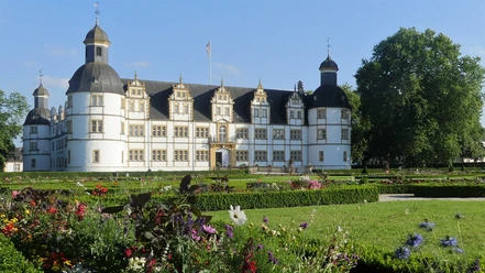
At the end of the Padersteinweg, we turn right towards Lake Padersee. At the lakeshore, we turn left and follow the circular route to the outlet structure. We continue along the left bank of the river. After passing under two road bridges, we come to the Pader-Alme overpass. We cross the two bridges and shortly afterwards reach a round paved square with some flagpoles on the right. We continue along the Emilie-Rosenthal-Weg through the Schloß- und Auenpark, which leads in wide bends to Schloß Neuhaus. Shortly before the end of the Schloß- und Auenpark, we come to a triangle of paths where a statue of the Virgin Mary stands. We turn left, cross the Pader and continue along Im Quinhagen to the right. When we reach Schloßstraße, we turn left. This takes us to the parish church of St. Heinrich and Kunigunde. After crossing Residenzstraße at the pedestrian crossing, we enter Neuhäuser Schloßpark through the castle entrance gate. From here, we no longer follow the PaderWanderung signs.
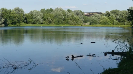
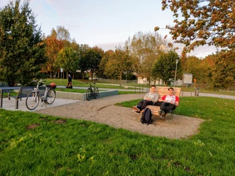
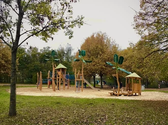
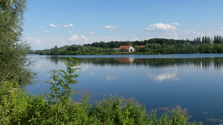
After the entrance gate, we keep to the right and walk towards the rose garden, behind which is the confluence of the Pader and Lippe rivers. At the level of the former commandant's office - today the office of the "Schlosspark und Lippesee Gesellschaft" - we turn left and walk along the moat of the castle to the municipal gallery in the riding hall. We come to the cobbled Marstallstraße, which we follow to the right. We walk past the Schloß Neuhaus grammar school in the direction of the open-air stage. At the fork at the end of the hedge, we keep left - straight ahead to the open-air stage. Shortly afterwards, we cross the Alme bridge and turn right at the next junction. On the left-hand side we see the floodplain playground, then a sports field and finally the so-called "Lippedrom" with its pentagonal sail roof. Once again we pass a bridge - this time over the Lippe, which has already absorbed the Alme at this point. Immediately before the bridge, this Boker canal is diverted, which now accompanies us to the end of the paved path.We turn left into the street Am Thunhof. Past the tennis court, our path runs across the grounds of the farm and a little later passes under the A 33 freeway. At the bend to the right, we leave the asphalt path and head straight on towards the Lippesee lake. Shortly after the barrier, we come to the Lippesee circular path. We continue along the circular path to the right, pass a wooded area and soon reach the off-road cycle course and the youth campsite. The Boker Canal flows beyond the asphalt path. We follow the gravel path along the off-road cycle course and playground. After passing the bridge over the Thune, our path leads across a parking lot. To our left is a basketball court, then the area of the "Eisklang" bistro with its sandy beach. This is followed by the clubhouse of the yacht club, the camper van site, the clubhouse of the sailing club and finally the "Seemöwe" bistro with pedal boat hire and mini golf course.At the T-junction near Sennelagerstraße, turn left. The road bends to the right and leads towards a former gravel works. We pass a barrier in front of the factory gate and then walk across the village square. We keep left and after a few hundred meters walk along the shore of the Lippesee again. Immediately before the pedestrian bridge, we leave the lake to the right, cross Sennelagerstraße and can already see the destination of our hike, the parish church of St. Marien, in front of us. From here, we have the opportunity to take the bus back to Paderborn.
Tour information
Familiy-Friendly
Stop at an Inn
Suitable for Pushchair
Equipment
Directions & Parking facilities
Parking for cars is available at Maspernplatz on the edge of Paderborn city center (destination address for the navigation system: Heiersmauer 45, 33098 Paderborn). There are usually plenty of parking spaces there.
Tip: Buy a reasonably priced day ticket! Further information on parking options and tariffs: www.asp-paderborn.de.
or lines 1, 2, 3, 4, 5, 7, 8, 9, 11, 12, 13/23, 14 (destination stop: Westerntor).
The return journey from Sande to Paderborn can be made with lines 4 and 9 (departure stop: Sande Schule).
Further information on how to get there by city bus is available at www.padersprinter.de or by telephone on 05251 6997222.
Additional information
Königsplatz 10
33098 Paderborn
Tel. 05251 8812980
tourist-info@paderborn.de
www.paderborn.de
www.facebook.com/paderborn.tourismus
www.instagram.com/paderborn.tourismus
Literature
Pocket book "Heimatwandern - Halbtages-Wanderungen im Paderborner Land, Eggegebirge und südlichen Teutoburger Wald" with 20 interesting circular tours through the local region (240 pages). Available for 15.80 euros from Paderborn Tourist Information, bookshops (ISBN: 978-3-9824645-0-3) and - free of charge - from HEFT-Zeitschriftenverlag (tel. 05251 62624).
Pocketbook "The most beautiful half-day hikes in the Paderborn region and Eggegebirge" with 20 interesting circular tours through the local region (220 pages). Available at a price of 12.95 euros from Paderborn Tourist Information, bookshops (ISBN: 978-3-9809507-8-7) and - free of charge - from HEFT-Zeitschriftenverlag (Tel. 05251 62624).
License (master data)

Author´s Tip / Recommendation of the author
Safety guidelines
Map
Photo Gallery


