Panorama trail | Circular hiking trail around Borgholzhausen


- 2:58 h
- 11.10 km
- 162 m
- 162 m
- 123 m
- 223 m
- 100 m
- Start: Am Ravensberger Stadion, Wichlinghauser Weg 2
- Destination: Am Ravensberger Stadion, Wichlinghauser Weg 2
The hiking trail runs for the most part through an open landscape that was formed during the last ice age ten thousand years ago, when the glacial masses coming from the north accumulated on the heights of the Teutoburg Forest and the meltwater poured into the plain at the mountain passage near Borgholzhausen. Researchers found hand axes, arrowheads and urn graves here - the oldest traces of human life from the Neanderthal period.
The names and landscapes of the individual sections of the trail are interesting and varied: "Haarberg", "Sundern", "Riesberg", "Barenberg".
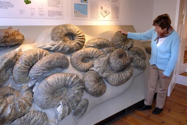
The Kultur- und Heimathaus with its ErdZeitCenter houses geological and geological exhibits, including the world's largest collection of giant ammonites and 240-million-year-old dinosaur tracks. With its small geological garden, the building is a major attraction in the Northern Teutoburg Forest Nature Park.


Waypoints
Good to know
Pavements
Best to visit
Directions
The 11 km long signposted panorama trail starts in the town center (at the Ravensberger Stadium) and leads around Borgholzhausen. The trail can be walked in both directions and offers hikers and walkers beautiful views of the idyllic little town nestled in the Teutoburg Forest from many places. It can be easily combined with other hiking trails such as the Burg Ravensberg Weg or the Luisenturmweg. Further information on the local hiking trails can be found on the town's website at:
https://www.borgholzhausen.de/sv_borgholzhausen/Tourismus/Freizeitangebote/Wandern/The hiking trail runs mostly on asphalted and paved paths through an open landscape that was formed during the last ice age ten thousand years ago, when the glacial masses coming from the north accumulated on the heights of the Teutoburg Forest and the meltwater poured into the plain at the mountain passage near Borgholzhausen. Researchers found hand axes, arrowheads and urn graves here - the oldest traces of human life from the Neanderthal period.
The names and landscapes of the individual sections of the trail are interesting and varied: "Haarberg", "Sundern", "Riesberg", "Barenberg". Starting clockwise from the sports stadium, you follow the Wichlinghauser Weg and the Hamlingdorfer Weg, where you cross the headwaters and floodplain of the Violenbach stream in a hollow. It runs through the town and collects all the rainwater from the slopes and the residential area. The Violenbach has been developed and ecologically enhanced to prevent flooding. You come to a gravel path along the edge of the Barenberg forest, which is largely owned by the state of North Rhine-Westphalia as a state forest. Storms in recent years, such as Kyrill in 2004 and Katharina in 2018, as well as the dry summers of 2018/19 have taken their toll on the spruce stands there, and the foresters are relying on natural regeneration.
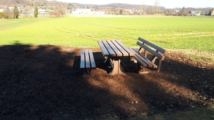
Here, shortly before the rest area at the waterworks fountain, we can branch off uphill for an extension of the loop to Ravensberg Castle, passing the elevated tank hidden in the slope as well as the filter building of the waterworks and the Clever Schlucht adventure forest.
On the actual route, we descend a few meters to a rest area newly created in 2019 with a wonderful view. To the north-west, you can see the wooded Johannisberg with the Luisenturm tower and next to it the Hollandskopf with the striking wind turbine on the site of the former NATO radar station. In the foreground, the view falls on the local plant of the Bielefeld-based company Schüco and a number of small businesses newly established "Am Stadtgraben". Particular attention should be paid to the spring area directly between Barenbergweg and the L785, which was renaturalized in 2019 by removing an old landfill site, including the floodplain of the Pustmühlenbach stream, which will change significantly in the coming years. Beyond the L785, we can clearly see the new Enkefeld residential development area behind the noise barriers.
Following the route, we go exactly there and cross the L785 comfortably at a traffic circle, on whose central square the two curved ellipses form the image of a heart when driving into the city from the south. This donation from the Schüco company is a reference to the town's slogan "The heart of the Teutoburg Forest" and symbolizes the gingerbread hearts from the Schulze company, which have made the "gingerbread town" famous far and wide and whose store and café in the town centre the route passes. The route leads through the development area past some modern flat-roofed buildings. On the left-hand side, very energy-efficient houses have been built in the climate protection estate on Regina-Spiegel-Straße.
We quickly leave the built-up area via Weststraße and Berghauser Weg into the hilly landscape of the Berghausen district. Turning right, the route is gentle at first and then somewhat steeper towards the end at the edge of the Johannisberg forest to the highest point of the Panoramaweg, which runs identically to the Luisenturmweg for a few meters and offers a corresponding detour to the Luisenturm. Through a wonderful hollow path, we take a forest path and finally a grassy path downhill towards the city center, where we can take another break at the edge of the forest with a beautiful view of the city center and the Teutoburg Forest.
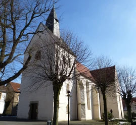
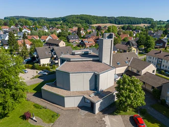
In the city center, we pass the Kultur- und Heimathaus, which houses the ErdZeitCenter in addition to other interesting exhibitions. This contains geological and geological history exhibits, including the world's largest collection of giant ammonites and 240 million-year-old dinosaur tracks, and is rounded off by a small geological garden. Next door is the aforementioned Schulze gingerbread café and store. The panorama trail leads through the town center past the town hall, built in 1976, the community center and the Catholic church. An idyllic path "Am Tempel" leads to the Künstlerhaus, affectionately known as the "Kroe-Haus". The Krömmelbein family lived here in modest circumstances. The park-like garden designed by Kroe and the lovingly furnished house are to be preserved and made accessible to the public.
From here, the route leads uphill, first along a wide asphalt road, then along a section of gravel path and then without a path along a grassy slope. This sundern was used for military purposes from 1963-1984, which explains the wide access road and the fence that still exists. The fire control center (Integrated Fire Control, IFC) was located here and belonged to the Dutch Nike-Hercules radar station. The missiles stationed there were to be controlled from this location by means of analog radar radio commands.
The view back towards Borgholzhausen, with a 220 kV overhead line in the foreground. This is to be expanded to 2*380 kV as an important electricity highway from the coast to the Ruhr region. Underground cabling is planned to protect the people in the directly adjacent residential areas and the landscape.
The route follows the paved "Heidbrede" path, which is very easy to walk on, and is slightly hilly with wonderful views of the city below Johannisberg with Luisenturm and Hollandskopf back to Wichlinghauser Weg and back to Ravensberger Stadion.
Tour information
Loop Road
Stop at an Inn
Equipment
Sturdy footwear
Binoculars
Don't forget your camera
Directions & Parking facilities
Address for navigation devices: Wichlinghauser Weg 2, 33829 Borgholzhausen
About 150 m further on, the hiking trail starts
Additional information
License (master data)
Tamara Kisker

Author´s Tip / Recommendation of the author
Safety guidelines
Download GPX file
Photo Gallery


