Of springs and stones near Borgholzhausen - Hermannshöhen tour tip 08


- 6:15 h
- 20.92 km
- 474 m
- 474 m
- 121 m
- 299 m
- 178 m
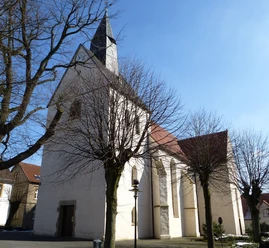
- Start: Borgholzhausen Protestant Church
- Destination: Borgholzhausen Protestant Church
On this circular tour through Borgholzhausen's hinterland, you will be walking over seabed that is thousands of years old. The rock strata of the two parallel ridges of the Teutoburg Forest mainly date back to the Cretaceous period, when Borgholzhausen still lay in a tropical sea, so to speak. Today, some steep climbs require a certain amount of stamina and physical fitness to reach the ridges of the mountain range.
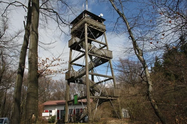
Today, three lookout towers along the route act as lighthouses over this ancient sea, offering magnificent views of the Osnabrück and Ravensberg hills and the narrow ridge of the Teutoburg Forest. At the summit of the Johannisegge, the Luisenturm tower invites you to linger, especially at dusk, when the sun slowly sets over the Dörenberg and Steinegge.
The numerous springs and lakes along the way are also characteristic of the hiking route. The Blue Lake, which is fed by a number of karst springs, resembles an idyllic forest oasis. In the Pusken valley, the source area of the Hase (tributary of the Ems), your hike takes you to the Black Wave. The Hasequelle and Uhlenquelle springs are also located in the Pusken valley.
In Borgholzhausen, it is worth visiting the Kultur- und Heimathaus with its ErdZeit-Center. Here you will encounter the tropical sea of Borgholzhausen again with a fossil exhibition and impressive ammonites!


Waypoints
Good to know
Best to visit
Directions
From the Protestant church in Borgholzhausen, turn left out of town > follow the Hermannsweg trail markings for the first third of the hike > cross the main road at the petrol station > take the narrow grassy path through the farmland up to Johannisegge > follow the markings uphill in the forest > before the forest thins out into pastureland again, the path takes a sharp right onto a narrow path that continues quite steeply uphill > at the next spur road, follow the path further uphill to the first destination, the Luisenturm tower.
From the Luisenturm, the Hermannsweg now leads across a parking lot and a stretch of asphalt road > keep left until you reach the fence of a wind turbine > continue left onto the hiking trail > follow the fairly well-maintained path of the Hermannsweg > at the large spider trail, turn diagonally right uphill > turn right at the clearing with a bench for a break, past the bench > follow the hiking trail to the tower on the Steinegge.
Behind the tower, the Hermannsweg leads over an old hollow path with a bridge > leave the quality trail and turn sharp right > the path bends left downhill, take the grassy path uphill on the right > continue along the path > pass the bench on the left until you reach a gravel path > turn right > follow the maple path markings slightly downhill > at the large oak tree, turn sharp right onto a path > at the next spur turn sharp left and continue along the maple path > after a while you will reach a wider path with signs > continue left until you reach the Blauer See lake.
Behind the Blue Lake, follow the maple path to the right along the gravel path > at the spider turn diagonally right into the small path and pass a small bridge > follow the path to the Almaquelle > continue out of the forest onto an asphalt road > turn left > take the 90 degree bend to the right and pass individual houses until you reach the next edge of the forest.
Before the edge of the forest, leave the road on the right > up the field path > before the next farmstead, you can take a detour to the Beutling observation tower > (same route from the tower back to the starting point) > continue along the private path of the farmstead to the main road.
Cross the main road straight ahead > follow the narrow path through the forest > cross the next road onto the narrow meadow path, diagonally right at the edge of the forest > continue straight on through the forest until you reach a deeply washed-out stream bed > cross > turn left onto a field path > follow this for a good distance > turn left again in the forest > watch out! The next fork is very hidden and leads through the forest to the right until you cross a small stream > If you miss this fork, follow the path until it meets a second forest path at an acute angle and turn right onto it. Then follow the X to the left as far as the stream
.After crossing the stream, cross a meadow towards a high seat > turn left before the high seat > follow the path > opposite the northernmost point of the district of Gütersloh, take the X path onto the forest path > follow the wide forest path for quite a long time until it ends > keep left at the main road > turn directly back into the "Hengbergweg" road > follow the road until you reach the residential area of Borgholzhausen.
At the main road, turn right for a short distance > cross the main road and turn left into "Martin-Luther-Straße" into the town center > at the next fork in the road into "Klockenbrink" until you reach the town administration > turn right into Schulstraße > next left into Kaiserstraße until you reach the starting point.
Tour information
Loop Road
Equipment
Directions & Parking facilities
Public parking spaces in Borgholzhausen
Luistenturm parking lot for hikers
Borgholzhausen train station. Continue by PIUM bus to Borgholzhausen town center.
For central information on public transport, please use the "smart number" for bus and train:
0180 6 50 40 30 (20 cents/call from a German landline, mobile max. 60 cents/call)
Electronic timetable information: 0800 3 50 40 30 (free of charge)
Timetable information online: www.teutoowl.de
From 01.08.2017, the Westphalia tariff will apply.
Additional information
Literature
License (master data)
Projektbüro Hermannshöhen

Author´s Tip / Recommendation of the author
Map
Download GPX file
Photo Gallery


