Der Osterbergweg


- 2:30 h
- 7.61 km
- 141 m
- 142 m
- 100 m
- 239 m
- 139 m
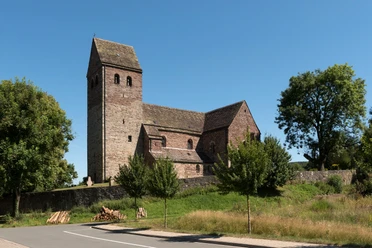
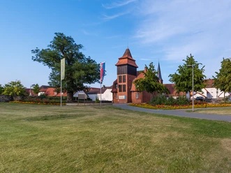
- Start: St. Kilian' Church Lügde
- Destination: St. Kilian's Church Lügde
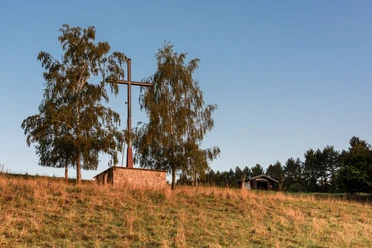
The starting point of the hike is the historic St. Kilian's Church at the southern end of the city. From here the hike leads along the Eschenbach into the beautiful Meintetal. After a first break at the original sources of the Eschenbach - the "Seven Sources", the ascent of the Osterberg begins. After a little refreshment in the "Hotel Kempenhof" mountain restaurant, you will reach the Osterberg. A lounger and a refuge invite you to take another break and offer a wonderful view over the Lügder and Bad Pyrmont basins. This is also where the Osterbergkreuz is located with the point where the massive, burning oak wheels roll down into the valley every year on the evening of Easter Sunday. The descent back into the city begins from the Osterberg. In the park of the Emmerauenpark, the Ankerplatz café invites you to take another rest. The outside area offers an excellent view of the Osterberg. Then the hike leads back to the starting point.
989 / 5000
Übersetzungsergebnisse
The starting point of the hike is the historic St. Kilian's Church at the southern end of the city. From here the hike leads along the Eschenbach into the beautiful Meintetal. After a first break at the original sources of the Eschenbach - the "Seven Sources", the ascent of the Osterberg begins. After a little refreshment in the "Hotel Kempenhof" mountain restaurant, you will reach the Osterberg. A lounger and a refuge invite you to take another break and offer a wonderful view over the Lügder and Bad Pyrmont basins. This is also where the Osterbergkreuz is located with the point where the massive, burning oak wheels roll down into the valley every year on the evening of Easter Sunday. The descent back into the city begins from the Osterberg. In the park of the Emmerauenpark, the Ankerplatz café invites you to take another rest. The outside area offers an excellent view of the Osterberg. Then the hike leads back to the starting point.


Waypoints
Good to know
Pavements
Best to visit
Directions
Route markings
Tour information
Familiy-Friendly
Good Connection to public Transport
Labelling
Loop Road
Mainly Sunny
Possibility of Accommodation
Premium Trail "Wanderbares Deutschland"
Stop at an Inn
Suitable for Bike
Tour with Dog
Directions & Parking facilities
Additional information
More information
Literature
Buchtipp: Lippe zu Fuß erleben (Herausgeber: Lippischer Heimatbund)
14,80 €
Erhältlich in der Tourist-Information Lügde
Contact person
License (master data)

Author´s Tip / Recommendation of the author
Safety guidelines
Map
- Wanderkarte Lippischer Südosten im Maßstab 1:25 000 (Herausgeber: Lippischer heimatbund) 6,95 €
- Schatzkarte von Lügde und Schieder-Schwalenberg (kostenlos)
Beide Karten sind in der Tourist-Information Lügde erhältlich.
Download GPX file
Photo Gallery


