Schlossweg mit Querverbindung Brunnenweg | Rundwanderweg SHS

GPX

PDF

Bookmark

7.06 km long
round trip
Difficulty: medium
Regional hiking trail
  • 01:42 h
  • 13 m
  • 13 m
  • 99 m
  • 112 m
  • 13 m
  • 7.06 km
  • Start: Am Schloss (near the Holte hunting lodge), 33758 Schloß Holte-Stukenbrock (111 m)
  • Destination: Am Schloss (near the Holte hunting lodge), 33758 Schloß Holte-Stukenbrock (111 m)
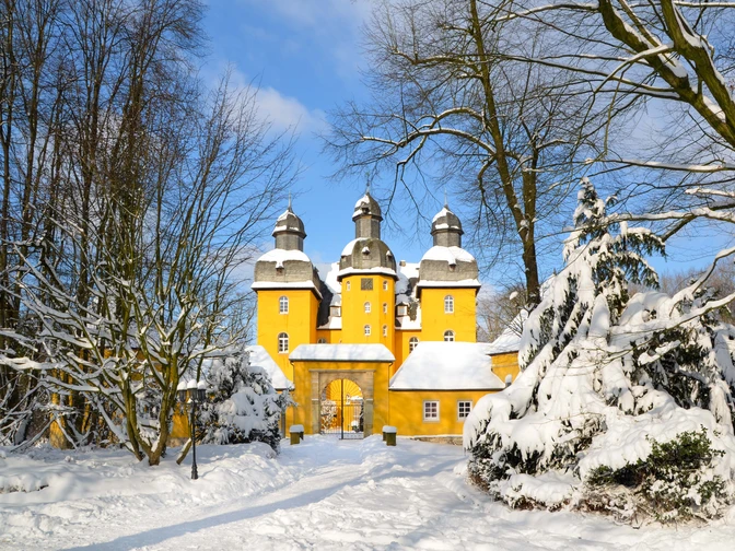
The Schlossweg connects the hunting lodge in Schloß Holte with Verl. The Brunnenweg cross-connection turns the original 12.8 km long trail into a circular trail of just 7.1 km.

This hiking trail leads mostly through the Holter forest. From the hunting lodge in Schloss Holte, follow the forest path for approx. 3 km following the Schlossweg signs until you turn left onto Brunnenweg. This connects the north and south tangents of the Schlossweg. Follow the Brunnenweg for a few hundred meters and then continue along the Schlossweg in the direction of Schloß Holte. Back on your original route, you will quickly reach the Mühlcafé on the edge of the forest in Verl with its quaint terrace by the mill wheel. The hiking trail then leads another 3 km along the banks of the natural Ölbach stream through sometimes dense, sometimes loosely overgrown forest and through meadows back to Holte hunting lodge, where the Holter Schlosskrug also invites you to linger.

Waypoints

Start
Am Schloss (near the Holte hunting lodge), 33758 Schloß Holte-Stukenbrock (111 m)
© Teutoburger_Wald_Stadt_Schloss_Holte-Stukenbrock_SFindhof, Susanne Findhof
1000-jährige Eiche mit Selfie Point SHS
Vantage point/Observation tower

Good to know

Best to visit

suitable
Depends on weather

Directions

The circular hiking trail is marked in both directions with the Schlossweg logo, three orange towers on a white background. After approx. 3 km (regardless of which direction you are walking in), you briefly follow the logo of the Brunnenweg to then rejoin the Schlossweg.

Tour information

  • Familiy-Friendly

  • Labelling

  • Loop Road

  • Nature Highlight

  • Stop at an Inn

  • Suitable for Bike

  • Tour with Dog

Equipment

Sturdy shoes are an advantage!

Directions & Parking facilities

A33, exit 22-Schloß Holte-Stukenbrock, direction Schloß Holte. Cross the traffic circle (second exit straight ahead). After approx. 800 m turn right into the forest.
At the edge of the forest (opposite Verler Landstraße 13, 33758 Schloß Holte-Stukenbrock)

Senne-Bahn Bielefeld - Paderborn: Schloß Holte station (1.7 km).


Bus route 83 Schloß Holte > Bielefeld > Schloß Holte: "Schloßkrug" bus stop.


Always know what's running: The smart number for buses and trains in NRW: 01806 504030 (20 cents/connection from landlines and a maximum of 60 cents/connection from mobile networks.)

Additional information

www.erfolgskreis-gt.de

www.teutoburgerwald.de

The hiking trail is included in the free map of the town of Schloß Holte-Stukenbrock and of course at www.stadt-shs.de.

Literature

Town map of Schloß Holte-Stukenbrock and brochure "The most beautiful hiking routes in Schloß Holte-Stukenbrock

Author´s Tip / Recommendation of the author

The Mühlcafè is a very cozy place to sit on the terrace by the mill wheel and the Holter Schlosskrug has an idyllic beer garden to offer!

Safety guidelines

Pay attention to the condition of the paths, which can change depending on the weather. Use the roads and paths at your own risk.

Map

City map of Schloß Holte-Stukenbrock
Getting there
Stadt Schloß Holte-Stukenbrock
Rathausstraße 2
33758 Schloß Holte-Stukenbrock
Bad Salzuflen: feel-good place
Our tip

Nature without detours

© Teutoburger Wald Tourismus / D. Ketz
Experience nature
Our tip

Exciting quality hiking trails

© Touristikzentrum Westliches Weserbergland
Travel planning on the road

Teuto-Navigator ►

© Teutoburger Wald Tourismus / D. Ketz