Norderteich Rundweg

GPX

PDF

3.44 km long
Difficulty: easy
Regional hiking trail
  • 00:40 h
  • 28 m
  • 28 m
  • 153 m
  • 171 m
  • 18 m
  • 3.44 km
  • Start: Norderteich hiking parking lot
  • Destination: Norderteich hiking parking lot
Billerbeck is located right next to the "Lippe Sea". This is what the Norderteich is called by the locals. It is located in the middle of a nature reserve and bird sanctuary. Nature calls the shots here. Fresh air and the village character of the place give all guests a contemplative break from hectic everyday life.

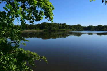
The hike leads around the Norderteich pond and the 22-hectare nature reserve with wild boar enclosure. Along the 3.4 km, you should enjoy the diverse flora and fauna. In the middle of the route, the Entenkrug invites you to enjoy a coffee and a piece of cake in a cozy atmosphere. The viewpoint at the end of the route offers a breathtaking view over the entire Norderteich.

Waypoints

Start
Norderteich hiking parking lot
Norderteichausblick
Vantage point/Observation tower
Destination
Norderteich hiking parking lot

Good to know

Best to visit

suitable
Depends on weather

Directions

You start your circular walk at the hiking parking lot. From there, walk straight ahead towards the forest. You come to a small crossroads, which you also cross straight ahead. From here you walk on a gravel path. Follow this until you reach asphalt again after a right-hand bend. Stay on this until you reach the Entenkrug restaurant. From here, a few meters further on, turn right again at the next crossroads so that Beller Holz is on your left. Continue along the forest to the next crossroads. Turn right again here, up the hill. This path takes you through a housing estate. After a small bend to the right and then a bend to the left, you reach the next crossroads. Take the right-hand path here. Follow this until you reach the crossroads. You are now back at the first crossroads, turn left here and you will return to your starting point, the hiking parking lot.

Tour information

  • Familiy-Friendly

  • Stop at an Inn

Equipment

Camera, binoculars

Directions & Parking facilities

A33, exit no. 26 Paderborn-Elsen, then B1 direction Hamel, exit Billerbeck. Turn right immediately until the next junction, then turn right. At the end of the road turn right. Follow the road. Shortly before entering Billerbeck, turn left into the hiking parking lot.

A2, exit 35 Bad Eilsen, direction Rinteln, city bypass, then via Barntrup and Blomberg direction Höxter, on the Ostwestfalenstraße exit Steinheim. Straight ahead, through Billerbeck, shortly after leaving the town turn right into the hiking parking lot.

Norderteich hiking parking lot on Steinheimerstraße, outside Billerbeck.
Train stations in Horn-Bad Meinberg, Leopoldstal and Steinheim (Westfl.) with direct connections from Bielefeld, Herford, Lage, Detmold, Paderborn and Hanover.

With bus route 776 in the direction of Steinheim. Get off at the Bad Meinberg-Belle, Entenkrug stop. From here in the direction of the Entenkrug restaurant. You now start in the middle of the tour.

Additional information

Author´s Tip / Recommendation of the author

Halfway along the route, you will come across the "Entenkrug" restaurant. This is a good place to stop for a snack.

Stop briefly at the viewpoint just before the end of the route. The view over the entire Norderteich is unique.

Safety guidelines

The cycle/walking tour is a circular route. You can start and finish at any point along the route.

The tour is also easy to manage with normal shoes.

Getting there
Norderteich Rundweg
32805 Horn-Bad Meinberg