- 3:00 h
- 10.78 km
- 193 m
- 194 m
- 185 m
- 368 m
- 183 m
- Start: Paderborn-Neuenbeken, hikers' parking lot on the L 755
- Destination: Paderborn-Neuenbeken, hikers' parking lot on the L 755
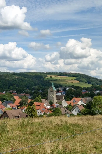
The hike initially takes around half an hour from the hiking parking lot through the beautiful Beketal valley. This is followed by an equally long ascent through beautiful beech forest to the Burenlinde, the highest point of the tour at 368 meters. From there, the route descends almost continuously. The former Bad Lippspring forester's lodge and the thatched hunting lodge of the Duke of Holstein-Glücksburg are located in the Lippspring forest along the way. Past the "Große Brichkuhle", one of the largest sinkholes in the region, and Hindahls Kreuz, the path leads to the Papenberg viewpoint. Finally, the trail descends quite steeply into the Beketal valley to the starting point.
Waypoints
Good to know
Pavements
Best to visit
Directions
Stage 1: Parking lot L 755 - Burenlinde [4.6 km]
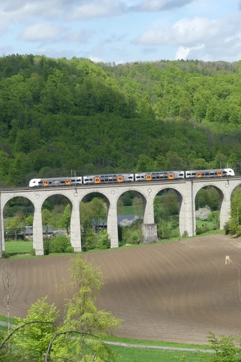
We head onto the road that starts at the parking lot, where we cross the Beke after just under 100 meters. The stream bed is often dry here, however, as the water from the Beke seeps into the limestone bedrock upstream. At the T-junction, we turn right (signpost: Paderborner Höhenweg = PHW). We now walk along the edge of the forest for about half an hour through the Beke valley below Papenberg and Kleinem Kobbennacken. In spring, we see numerous flowers here, such as larkspur, yellow wood anemones and primroses. On the other side of the valley, we can see the Dune Valley railroad viaduct, built in 1852, and in front of it the Dunehof with its 100-year-old house.
About one kilometer further on, we reach a fork in the path, near which there is a large electrical switch box and a memorial stone with old field names in the forest on the right. We head to the right. 100 meters further on, another path branches off to the right - and with it the Paderborner Höhenweg - in the direction of the L 755 country road. Here, too, we can see another Beke bridge 50 meters away. In contrast to the previous point, the Beke normally carries water here. We keep straight on at this junction and now walk for about 800 meters on the viaduct hiking trail (VWw). Shortly before a shed at the edge of a pasture, we turn left onto a narrow hiking trail (signposted VWw). This runs only about two meters from the pasture fence and climbs noticeably. At the top corner of the pasture, we follow the bend to the right and the gradient becomes more moderate. At the end of the narrow natural path, we have three options: We head straight ahead onto the gravel path (signpost: A3). This takes us off the viaduct hiking trail, which branches off to the right here.
Now we face the most strenuous section of this hike: for almost half an hour, we climb continuously up the slope of the Kobbennacken, overcoming around 140 meters in altitude. In spring, we can see and smell wild garlic over large areas down the slope into the Durbeke valley. At the top, our forest path describes a sweeping left-hand bend and meets a tarmac path, where we keep left (signpost: A3). Now it is another 300 meters on the asphalt path until we reach the highest point of our hike at 368 meters, the Burenlinde. It was planted at the time of the Second Boer War around 1900 by the then forester out of enthusiasm for the Boers' quest for independence in what is now South Africa. If we feel like taking a break after the strenuous climb, we can stop at the refuge a few meters further on.Stage 2: Burenlinde - Hindahls Kreuz [4.0 km]
Immediately at Burenlinde, we turn off onto the "Alter Stadtweg", an old connecting path between Paderborn and Horn (signpost: A3). We now walk along this gravel path for around a quarter of an hour through the sparse beech forest. At the "Naturschutzgebiet" (nature reserve) sign, we turn right (no hiking markings). At the next crossroads, we turn left. The gravel path describes a wide bend to the right. Then the forest thickens. We are now in the forest area known as "Dunenberg" or "Dumberg", which was sold by the town of Bad Lippspringe to the Duke of Schleswig-Holstein-Glücksburg-Sonderburg in 1934. Shortly after a right fork, we see a half-timbered house on the left, the former forester's lodge of the town of Bad Lippspringe. We follow the 90-degree left-hand bend and reach the entrance to the property. From here, we can also see the duke's thatched hunting lodge behind the half-timbered house. At the entrance to the property, we keep straight on. We follow the bend to the right and continue on a well-maintained gravel path through the forest (signpost: A2). We ignore the first forest path branching off to the left. A good 400 meters further on, we turn left, then right after another 100 meters (signpost: A2). After around 600 meters, in a hollow, it is worth taking a detour to the path branching off to the right to the "Große Brichkuhle", the largest sinkhole in the region, 50 meters away. This sinkhole has a diameter of over 35 meters and a maximum depth of 25 meters. We pass a red and white barrier, come to an asphalt path, turn left and shortly afterwards reach the crossroads at Hindahls Kreuz. Keep straight ahead here.
3rd stage: Hindahls Kreuz - L 755 parking lot [2.2 km]
Passing the overview board for the Paderborn High Trail, which we can now use to find our way to the Papenberg viewpoint, we walk along the gravel road at the edge of the forest. Shortly after entering the forest, we reach a triangle of paths. We keep to the right there. At the junction a good 100 meters further on, we also choose the right-hand alternative, remaining on the gravel road (signpost: PHW). About five minutes later, we see an information board on the left-hand side about the Hanstein sinkhole, which is located a few meters from the path in the forest. About 300 meters further on, a path branches off to the right to the Papenberg viewpoint, which is about 150 meters away from here. This short detour is worthwhile: from there, we can enjoy a magnificent view over Neuenbeken and Benhausen as far as Paderborn and the Hellwegebene. There is also a picnic area and a lounger in the countryside. We walk back to the junction at the edge of the forest. There we keep to the right and leave the Paderborn High Trail. It goes downhill. After a good 200 meters, the gravel road bends to the right and we turn left at this fork. We now descend quite steeply. Go straight ahead at the crossroads. About 150 meters further on, at the T-junction, we turn right. This is immediately followed by a sharp left-hand bend. From here, the signs for the Paderborn High Trail show us the direction again for around 1.5 kilometers. The gravel path leads us gently down into the Beketal valley. Shortly before the bottom of the valley, we see the former quarry at Hanstein on the left, where the next picnic group invites us to take a break. At the bottom of the valley, we turn right and reach our starting point after a few minutes.
Tour information
Loop Road
Equipment
Directions & Parking facilities
The parking lot is only a few meters away from the bus stop.Further information on how to get there by regional bus can be found at www.fahr-mit.de or by calling 05251 2930400.
Additional information
Literature
Pocketbook "The most beautiful half-day hikes in the Paderborn region and Eggegebirge" with 20 interesting circular tours through the local region (220 pages). Available for 12.95 euros from Paderborn Tourist Information, bookshops (ISBN: 978-3-9809507-8-7) and - free of charge - from HEFT-Zeitschriftenverlag (Tel. 05251 62624).
License (master data)
Author´s Tip / Recommendation of the author
There are several other beautiful hiking trails in the area, such as the Paderborner Höhenweg, the Viadukt Wanderweg or the Walderlebnis-Pfad of the Naturerbe-Wanderwelt Altenbeken.


