Weser-Lutter-Weg


- 3:30 h
- 10.96 km
- 52 m
- 4 m
- 78 m
- 119 m
- 41 m
- Start: StadtBahn stop Buschbachtal
- Destination: StadtBahn stop Adenauerplatz
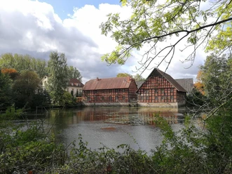
The route begins by crossing the Dankmarsch nature reserve and continues past the Schelphof nature education center and the historic Meyer zu Heepen farm. Along the course of the Weser-Lutter stream, through the Lutter green corridor, you reach the inner-city area. Shortly before the destination, the Kunsthalle sculpture park, the trail runs along the section of the Weser-Lutter in the city center that has only just been opened up again.


Waypoints

Good to know
Pavements
Best to visit
Directions
You start in a southerly direction at the Buschbachtal StadtBahn stop and cross Milser Straße. There is now a farm on your left, follow the path and after approx. 150 m you will reach the edge of the Dankmarsch nature reserve. Cross the nature reserve until you come to the "Großes Holz" road. Cross this road and continue along the path. At the next fork in the path, keep right, follow this path for approx. 500m and then turn left. The path now runs along the edge of a small wood on your right for approx. 50m and then leads into the forest. After approx. 250m, cross the Vogelbach stream and turn right at the next fork. Follow the path to Hof Schelpmeyer, crossing the Lutter shortly before you reach it. From the farm, follow "Eckendorfer Str." for a short distance, then keep left to reach "Spreckelweg".
This runs parallel to "Eckendorfer Str." for approx. 450m to the underpass to cross it. Follow the path to "Vogteistraße", with the green corridor always on your right and the residential buildings on your left.
At "Vogteistraße", you have to walk a short distance to the left until you cross the road at no. 42 to get back to the green corridor. The Finkebach now runs to your right, with an allotment garden site to your left. At the next fork in the path, keep right and cross the "Holzbach". Keep left on the following path until you cross the "Holzbach" again. After this wooden bridge, turn right and then immediately left. On your left is a meadow and behind it the Heeper cemetery, on your right is a wood. After approx. 180m you will come to the "Lutterpatt", at this T-junction turn right and follow the path until you come to "Heeper Straße".
Cross the road, after approx. 120m you will reach the pond with a view of the Hof Meyer zu Heepen. Turn left so that the farm is on your right and follow the road that leads to the old mill and the weir. Once you have passed this, turn left into "Baderbachweg". After 170m, keep left again until you have crossed the Lutter.
Further on, the path leads through the Lutter-Grünzuge and you follow the route. The Weser-Lutter and the reservoirs should always be on your left. There is another pond on your left. First cross the road "Am Venn", then "Brückenstraße" and "Otto-Brenner-Straße". The Weser-Lutter is now on your right for a short distance until you cross it again at the railroad underpass. Follow the path in the direction of Stauteich I. Here you cross the "Walkenmühle" road and continue along the path in the green corridor. You are now walking parallel to "Ravensberger Straße", the Lutter is no longer visible. Continue crossing "Huberstraße" and "Mühlenstraße" and keep straight ahead in the green corridor, parallel to "Ravensberger Straße", until you come to "Teutoburger Str.". Leave the green corridor, cross the road and follow Ravensberger Str. until it meets Niederwall and ends.
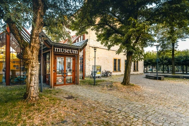
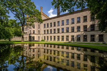
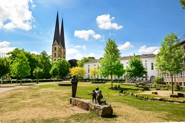
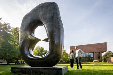
Turn right to cross Niederwall at the pedestrian crossing. Pass the large plane tree in the green corridor, a natural monument estimated to be around 280 years old, cross the street "Siekerwall" and enter the street "Am Bach". Follow the road for a short while, then you will see the Park of Human Rights on your left. Turn into the park so that the open Weser-Lutter flows on your left for the first stretch. At the upper end of the park, the former Haus des Handwerks is in front of you, and follow the course of the Weser-Lutter. After crossing the Weser-Lutter one last time with the help of steps, you will now come to the "Nebelswall". Now keep to the right, with the art gallery and sculpture park on your left. The path now curves to the left around the park until you reach the weather house at the Kunstforum Stenner - you have now reached your destination.
Tour information
Premium Trail "Wanderbares Deutschland"
Equipment
Directions & Parking facilities
Start NAVIGATION ADDRESS: Milser Straße 85, 33729 Bielefeld
Destination NAVIGATION ADDRESS: e.g. Am Waldhof, 33602 Bielefeld
TIP: There are paid parking garages at the destination
Start: We recommend the park & ride parking lot at the StadtBahn stop Milse, from there you have to take the StadtBahn line 2 (direction Altenhagen), get off at the StadtBahn stop Buschbachtal.
Attention: There is no parking available at the StadtBahn stop Buschbachtal.
Destination: paid parking garages in the old town area, e.g. Am Waldhof, 33602 Bielefeld
Start: StadtBahn stop Buschbachtal (line 2, direction Altenhagen)
Destination: StadtBahn stop Adenauerplatz (line 1)
Literature
Hiking experience ZweiTälerLand
Publisher/Publisher: digitale Kartografie F. Ruppenthal GmbH
License (master data)
Umweltamt Bielefeld/Stadt Bielefeld

Photo Gallery


