Weiberg | Hiking trail W4
- 0:54 h
- 3.28 km
- 52 m
- 48 m
- 331 m
- 397 m
- 66 m
- Start: Büren-Weiberg, Wanderparkplatz Jüenwinkel
- Destination: Büren-Weiberg, Wanderparkplatz Jüenwinkel
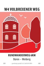
From the hiking parking lot, we turn left, past the paths to Molmsche and Frankenbach. We then turn right and after a while reach the Volbrexen estate, whose fortified tower can be seen in the logo of the hiking trail. Here we turn right along the field path and then continue along the edge of the forest until we reach the starting point.

Circular hiking trail W4 "Volbrexener Weg" | Büren-Weiberg
Circular hiking trail W4 "Volbrexener Weg" | Büren-Weiberg
Wegmarkierung Rundwanderweg W4 bei Büren-Weiberg
Good to know
Best to visit
- suitableDepends on weather
Route markings
- Wegmarkierung: "W4 Volbrexener Weg" (schwarze Schrift auf weißem Grund mit Abbildung "Turm" auf rotem Hintergrund)
Tour information
Familiy-Friendly
Loop Road
Equipment
- Festes Schuhwerk empfohlen
Directions & Parking facilities
- Getting thereAus Richtung Büren kommend über die Kreisstraße 35 bis nach Weiberg. Der Ortsdurchfahrt folgen und hinter der Schützenhalle am Kriegerdenkmal links einbiegen (Volbrexener Straße). Dem Weg bis zum Wanderparkplatz am Waldrand folgen.ParkingParkmöglichkeit am Wanderparkplatz "Jüenwinkel" (Volbrexener Straße).Public transportationFahrplanauskunft:Nahverkehrsgesellschaft Hochstift mbH
Tel. +49 5251 123366 | www.hochstiftbewegt.de
Download GPX file
Photo Gallery


