Tönsberg views - A5
.JPG")
.JPG")
.JPG")
- 1:52 h
- 6.92 km
- 85 m
- 85 m
- 227 m
- 311 m
- 84 m
- Start: Hikers' parking spaces on the road "Unter der Howe"
- Destination: Circular hiking trail Starting point = destination
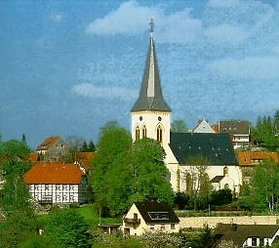
Simply switch off for a while and take a deep breath! This circular trail offers beautiful views in all directions. With a refreshing break at the water treading pool at Schnaken Karlchen, the starting point is reached again after approx. 2 1/2 hours. The trail starts at the old vicarage. There are two wonderful natural monuments here, the parish lime tree and an old ash tree. The old village well is a reminder of the time without a central water supply in Oerlinghausen. The rest of the hike offers wonderful views to the south towards Paderborner Land and Sauerland. You walk through the beautiful mixed forest past the water treading basin, where the Sachsenquelle spring rises on the southern slope of the Tönsberg. The spring is part of the "Wallburg Tönsberg" ground monument. Further on, you will reach a vantage point below the Hünenkapelle chapel with spectacular panoramic views. The rest of the route to the north also offers wonderful views and insights time and again.


Waypoints
Good to know
Pavements
Best to visit
Directions
Tour information
Loop Road
Premium Trail "Wanderbares Deutschland"
Stop at an Inn
Equipment
Sturdy shoes and clothing suitable for the weather
Binoculars
Small towel for the Kneipp treading pool - Karlchen the snail is looking forward to your visit :-)!
Oerlinghaus hiking map "Hiking experience"
We recommend that you take the "Oerlinghauser Erlebnisguide" with you. The local hiking trails are described here in detail and informatively.
You can obtain the brochures from the tourist information office or download them from the homepage.
Directions & Parking facilities
via A33 - exit 22, Schloß Holte-Stukenbrock - L751 towards Oerlinghausen - after approx. 5.6 km (after tunnel) take L751/exit left towards Oerlinghausen - turn left onto L967/Zeppelinstr. - after approx. 100 m at the traffic lights turn right onto "Robert-Koch-Str." in the direction of the glider airfield - after approx. 500 m turn left onto "Küsterfeld" - turn left onto "Unter der Howe" - after approx. 100 m there is a parking lot for hikers "Unter der Howe", unlimited parking.
Take the A2 - exit 27, Bielefeld Zentrum - B66 towards Oerlinghausen - exit towards Oerlinghausen - after approx. 4.7 km take the L751/exit right towards Oerlinghausen - turn left onto Zeppelinstr. 400 m at the traffic lights turn right onto "Robert-Koch-Str." towards the glider airfield - after approx. 500 m turn left onto "Küsterfeld" - turn left onto "Unter der Howe" - after approx. 100 m parking lot "Unter der Howe", unlimited parking available.
Oerlinghausen - Hikers' parking lot "Unter der Howe"
Line 34 stop Ev. Altenzentrum > street "Küsterfeld" opposite uphill > street "Unter der Howe" to the left until hiking parking lot
Line 39 stop Simonsplatz > through Pfarrstraße in the direction of Alexanderkirche > keep right to the hiking parking lot
Bus route 38 - Oerlinghausen station (in Asemissen!) - shuttle bus to Oerlinghausen Marktplatz
Overview of bus route/timetables at:
Additional information
License (master data)
Stadt Oerlinghausen

Author´s Tip / Recommendation of the author
Alexanderkirche usually open on Sundays from 14:00 - 17:00
Take a detour into the old town of Oerlinghausen
Historic inns, beer gardens, cafés and snack bars
Safety guidelines
Map
Local hiking map "Erlebnis Wandern" Wanderbares Oerlinghausen zu Fuß entdecken current 2nd edition 07/2021
Available free of charge from the Oerlinghausen town hall office, Rathausplatz 1, Oerlinghausen or as a download at www.oerlinghausen.de
Download GPX file
Photo Gallery


