Spazierwanderung Paderborn: Drei-Seen-Weg bei Schloß Neuhaus


- 1:30 h
- 6.67 km
- 60 m
- 60 m
- 111 m
- 128 m
- 17 m
- Start: Habichtsee lake on Habichtsweg in Paderborn-Schloß Neuhaus
- Destination: Habichtsee on the Habichtsweg
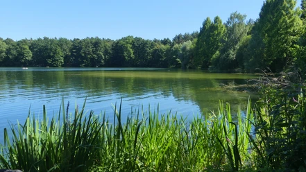
The Three Lakes Trail introduces you to three tranquil lakes on the edge of the Senne in the north-east of Paderborn: Habichtsee, Waldsee and Talleseen, which are only separated by a narrow strip of land.
All of them are "man-made", created by sand extraction, although this is hardly noticeable. Today, the lakes are used for recreation: people sunbathe on the sandy beach of the Habichtsee, camp at the Waldsee or take a walk, often with a dog, around the Talleseen.
Waypoints
Good to know
Best to visit
Directions
Stage 1: Habichtsee - Talleseen: 3.6 km
From the Habichtsweg trail, we first walk along the lakeside path that runs parallel to the road, keeping to the right at the end of the lake and heading towards the sandy beach. After a short climb, a hiking trail leads into the pine forest on the left, which is easily recognizable by the barrier and a sign indicating the military training area (note: this could give the impression that this trail is closed to hikers. However, this is definitely not the case: the sign clearly shows a blue "Pedestrians permitted" sign). This leads us relatively straight through the forest. The unfortunately mostly faded "blue dot on a white background" marking can serve as a guide not only here, but throughout the entire hike.
We follow the path through the Kiefenwald forest and ignore the paths branching off to the side until there is a paddock to our left. There we come to a fork where we keep to the right, i.e. continue on the path that is permitted for pedestrians. We turn right before the fence of the British Athlone barracks, which has a green screen, and continue along the fence. After just under 200 meters, we reach Husarenstraße, cross it and head into the entrance to the "Am Waldsee" campsite. We keep straight on, walk past the campsite restaurant and, after walking past the privacy fences, reach the shore of the Waldsee. We turn right and walk around the lake shore. On the opposite side, at a red and white barrier, we change from the lakeside path to the asphalt farm track.
The asphalt ends at the height of a half-timbered house; we turn right. After 90 meters, at the end of the small wooded area, our path bends to the left. We pass paddocks and come to a tarmac path, where we turn right. We cross the Hatzfelder Straße and go straight ahead onto the path that runs alongside the allotment site. Shortly before the end of the path, which meets the Schatenweg at the Talleseen lakes, is the Metternich monument, which commemorates Count von Wolff-Metternich, who died in a hunting accident. Continue along the Schatenweg to the right.
Stage 2: Talleseen - Habichtsee: 3.1 km
The Talleseen lakes are on the left. We follow the fairly wide footpath and cycle path (Schatenweg) in a straight line. Around 100 m before the crash barrier, between telephone poles no. 13 and 12, we turn right onto a footpath that leads into the forest. We cross the forest on this path, only a few meters from the edge of the forest, and meet the asphalted Westfalenweg. We turn left and then right at Trakehnerstraße. After about 200 meters, we cross Hatzfelder Straße and continue along Trakehnerstraße. At the next two crossroads (Ziethenweg and Dietrichstraße), we keep straight on. At the third crossroads (Trakehnerstaße/Marschallteich), we turn left in front of a dog training area. We continue along Kürassierweg to the right. We reach Husarenstraße, cross it, turn left and after 40 meters turn right into the forest path. Shortly afterwards, we pass a playground and a football pitch and after a few minutes we reach the Habichtsee lake and our starting point.
Tour information
Familiy-Friendly
Loop Road
Equipment
Directions & Parking facilities
Additional information
Königsplatz 10
33098 Paderborn
Tel. 05251 8812980
tourist-info@paderborn.de
www.paderborn.de
www.facebook.com/paderborn.tourismus
Literature
Pocket book "The most beautiful half-day hikes in the Paderborn region and Eggegebirge" with 20 interesting circular tours through the local region (220 pages). Available for 12.95 euros from Paderborn Tourist Information, bookshops (ISBN: 978-3-9809507-8-7) and - free of shipping costs - from HEFT-Zeitschriftenverlag (Tel. 05251 62624).
License (master data)
Karl Heinz Schäfer

Safety guidelines
Bathing and swimming in Lake Habichtsee and the other lakes is officially prohibited!
The Three Lakes Trail runs between Habichtsee and Waldsee in an area that belongs to the Senne military training area under British sovereignty. A few years ago, the British signposted this section as the "Senne hiking trail" - which often leads to confusion - and put up quite a "forest of signs" to ensure that no one enters the junctions, which are marked as closed by traffic signs. Please do not be confused by these numerous signs!
Map
Download GPX file
Photo Gallery


