R10 | Radrundweg in Borgholzhausen

19.92 km long
Round trip
Difficulty: easy
Condition: very easy
Regional bike tour
  • 1:30 h
  • 19.92 km
  • 215 m
  • 215 m
  • 97 m
  • 186 m
  • 89 m
  • Start: Bahnhofstraße near the Shell gas station
  • Destination: Bahnhofstraße near the Shell gas station
The 21 km long R10 circular cycle route leads through the Ravensberger Land region and is one of the classic cycle routes in the district of Gütersloh. Starting from the center of Borgholzhausen, the 21 km route runs via Winkelshütten, Barnhausen, Hamlingdorf, Nollheide and Berghausen. The route leads from Berghausen back to Borgholzhausen.

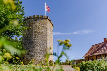
From the center of Borgholzhausen, the 21 km route runs via Winkelshütten, Barnhausen, Hamlingdorf, Nollheide and Berghausen. The route leads from Berghausen back to Borgholzhausen. There are two sights not far from this route that are well worth a detour. The 13th century moated castle of Brincke with its remarkable castle chapel and Ravensberg Castle, situated south of Borgholzhausen on a steep limestone ridge in the Teutoburg Forest. While the castle was once considered the defensive center of the country, today it is a popular excursion destination in the region with its 98 m deep, legendary well.

Waypoints

Start
Bahnhofstraße near the Shell gas station
Runder Burgturm aus Stein mit Zinnen und wehender rot-weißer Fahne bei klarem Himmel.
CC-BY-SA | Mario Wallenfang Fotografie
Burg Ravensberg
Fortress/Castle
Destination
Bahnhofstraße near the Shell gas station

Good to know

Pavements

Street
Asphalt
Gravel

Best to visit

suitable
Depends on weather

Directions

Borgholzhausen - Bahnhofstraße - Teutoburger Straße - Bielefelder Straße - Meller Straße - Winkelshütten - Wollenbrock - Landweg - Lohkamp - über den Violenbach - Barnhauser Straße - Zufahrt Barnhauser Straße - über die Bielefelder Straße - Zufahrt Bielefelder Straße 60 - Heidbrede - Heidbreder Weg - Schulzentrum - Wichlinghauser Weg - Zufahrt Wichlinghauser Weg 44 -52 - Hamlingdorfer Weg - via Violenbach - access road Hamlingdorfer Weg 26 -30 - Barenbergweg - access road to the rubble dump - Unter der Burg - Nollheide (access road to the Hagemeyer-Singenstroth house) - Bahnhofstraße - Am Bach - Wellenstraße - via Nollbrink - Berghauser Weg - Bahnhofstraße - Borgholzhausen

Tour information

  • Loop Road

Equipment

Camera and binoculars

Directions & Parking facilities

Coming from the A33, follow Versmolder Straße until you reach Bahnhofstraße. After approx. 2.5 km, turn right into Freistraße/ Ortsmitte.
Parking is available in the center of Borgholzhausen near the Protestant church on Kaiser-/Freistraße and Schulstraße.

Additional information

License (master data)

Tamara Kisker
License: Attribution, ShareAlike

Author´s Tip / Recommendation of the author

Visit Brincke moated castle from the 13th century with its remarkable castle chapel and Ravensberg Castle to the south of Borgholzhausen. While the castle was once considered the fortified center of the country, today it is a popular destination in the region with its 98 m deep, legendary well.

Map

The NRW district of Gütersloh, city of Bielefeld cycle map (scale 1: 50,000) is available from local bookshops. The price is € 8.50. The ISBN no. is: 978-3-936184-74-7.

Contact

R10 | Radrundweg in Borgholzhausen
33829 Borgholzhausen
Bad Salzuflen: feel-good place
Our tip

Nature without detours

© Teutoburger Wald Tourismus / D. Ketz
Experience nature
Our tip

Exciting quality hiking trails

© Touristikzentrum Westliches Weserbergland
Favourite time out in nature

Rheda-Wiedenbrück

© Teutoburger Wald Tourismus / D. Ketz

Photo Gallery