On the Hermannshöhen: The Eggeweg


- 18:00 h
- 70.56 km
- 920 m
- 926 m
- 246 m
- 462 m
- 216 m
- Start: Externsteine, Horn-Bad Meinberg
- Destination: Marsberg
Schon gewusst? Schon in vor- und frühgeschichtlicher Zeit wurde dieser Höhenweg als Heer- und Handelsstraße genutzt.
Kurzer Routenüberblick:
Von Nord nach Süd durchquert der Eggeweg bei einer Länge von 70 km das Eggegebirge und führt stets über den Kamm des Gebirges. Auf dem siedlungsfreien Kammweg gelangt man von den Externsteinen im Norden durch das Silberbachtal auf die 468 m hohe Preußische Velmerstot, die höchste Erhebung von Teutoburger Wald und Egge. Weiter geht es südwärts über den bewaldeten Eggekamm, der zahlreiche tolle Aussichten bietet. Auf dem weiteren Verlauf überrascht der Naturpfad mit zahlreichen eindrucksvollen Relikten aus der Geschichte des Landstrichs.
Achtung! - Bad Driburg braucht ihre Hilfe!
Derzeit werden in und um Bad Driburg von unbekannten Tätern sämtliche Markierungszeichen und Wegebeschilderungen mutwillig entfernt. Es ist bereits ein sehr großer Schaden entstanden und die Wanderer finden die Wege nicht mehr.
Wenn Sie Personen entdecken, die Markierungen oder Schilder entfernen, benachrichtigen Sie bitte direkt die Polizei oder die Bad Driburg Touristik unter Tel. 05253-98940. Vielen Dank für ihre Unterstützung und sorry, dass die Wege derzeit nicht korrekt markiert sind!
Stolz: Der Eggeweg ist der erste Fernwanderweg, der vom Deutschen Wanderverband als Qualitätsweg Wanderbares Deutschland ausgezeichnet wurde. Und nicht nur das, denn der Eggeweg ist der am längsten durchgehend zertifizierte Wanderweg Deutschlands.
#sehenswürdigkeiten entlang des Eggeweges:
- Die Externsteine
- Die Zwillingsgipfel Velmerstot
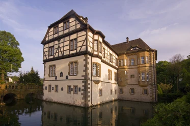
- Die Iburg-Ruine Bad Driburg
- Der gräfliche Park Bad Driburg
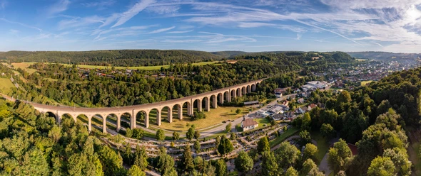
- Die historischen Baustelle “Alte Eisenbahn”
- Die Stadtwüstung Blankenrode mit Outdoor-Hörmuseum
Die Tour im Überblick:
Start: Externsteine, Horn-Bad Meinberg
Ziel: Marsberg
Strecke: 70,56 km
Zeit: 4,5 Tagesetappen
Schwierigkeitsgrad: mittel
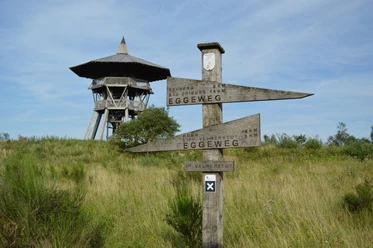
Wegkennzeichnung: Ein weißes liegendendes Kreuz (Andreaskreuz, X1).


Waypoints


Good to know
Best to visit
Directions
The Eggeweg is marked with a white horizontal cross (St. Andrew's cross, X1) in both directions by the Eggegebirgsverein. For the first few kilometers, it also runs parallel to the Hermannsweg "H". The Eggeweg is a section of the European long-distance hiking trail E1.
Hiker-friendly accommodation along the Hermannshöhen is designated as a "Hermannshöhen quality establishment" and marked as a recommendation in the stage suggestions.
Tour information
Multiday Tour
Premium Trail "Wanderbares Deutschland"
Equipment
Directions & Parking facilities
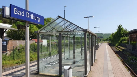
Other stations with access along the route: Leopoldstal, Sandebeck, Altenbeken, Bad Driburg, Willebadessen, Scherfede, Marsberg.
Always know what's running: The smart number for buses and trains in NRW:
08006 - 50 40 30 (free of charge from the German landline network).
Additional information
Literature
Date of publication: 2022 (4th edition)
Overall route Hermannshöhen (250km). Edition)
Total route Hermannshöhen (250km): scale 1: 35 000, weatherproof
Hiking map, city maps, list of overnight accommodation, elevation profile, thread stitching
ISBN: 978-3-85000-767-2
Price: €12.90, in bookshops
OUTDOOR hiking guide: Hermannsweg-Eggeweg
Publication date: March 2019 (4th edition)
Hiking guide: Hermannsweg-Eggeweg
Publication date: March 2019 (4th edition)
Outdoor hiking guide: Hermannsweg-Eggeweg
. Edition)
About the Hermannshöhen - interesting facts, accommodation, sights, stages, elevation profiles, hiking maps
ISBN: 978-3-86686-621-8
Price: €12.90, in bookshops
Contact person
Projektbüro der Hermannshöhen
License (master data)
Projektbüro Hermannshöhen

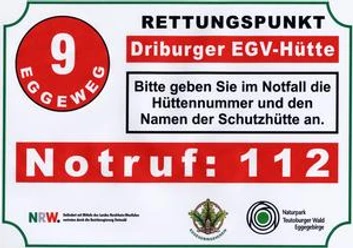
Safety guidelines
28 rescue points were created on the Eggeweg. They are used to indicate the location as precisely as possible in the event of danger so that the rescue station can find the scene of the accident promptly and reliably.
The following rescue points are registered with the emergency call center:1. Silbermühle, 2. Lippischer Velmerstot, 3. Preußischer Velmerstot, 4. Hakehütte, 5. Schwarzes Kreuz, 6. Rehberghütte, 7. Knochenhütte, 8. Heinrich Heine Hütte, 9. Driburger EGV Hütte, 10. Schöne Aussicht, 11. Klusenberg Hütte, 12. Radbaum Hütte, 13. Herbram Wald, 14. Asselner Hütte, 15. Paderborner-Berg-Hütte, 16. Willebadessener Hütte, 17. Johann Kiene Hütte, 18. Alte Eisenbahn- Hütte, 19. Krollhütte, 20. Borlinghauser Hütte, 21. Bördeweg Nadel, 22. Roters Eiche Hütte, 23. Mittelwald Hütte, 24. Blankenroder Hütte, 25. Felsberg Hütte, 26. Oesdorf Dorfplatz, 27. Essentho Ortsmitte, 28. Cafe Bleichhaus
This tour has far more than 500 waypoints. If you are using a GPS device, please ensure that the track is displayed in full! Shorter stage suggestions for the Eggeweg can also be found in the TEUTO_Navigator.<
Map
Publication date: 2021
Leporello: Scale 1:50.000, waterproof, tearproof, GPS-accurate
City maps, elevation profile, information on places of interest, list of overnight stays, refreshment stops
ISBN: 978-3-85026-984-1
Price: €8.99, from bookshops
Our recommendations


Photo Gallery


