Oerlinghausen - Archaeological hiking trail

GPX

PDF

Bookmark

3.56 km long
Difficulty: medium
condition: easy
Great panorama
Themed trail
  • 01:15 h
  • 129 m
  • 61 m
  • 210 m
  • 336 m
  • 126 m
  • 3.56 km
  • Start: Archaeological open-air museum - Oerlinghausen
  • Destination: "Wallburg Tönsberg"
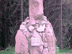
The Tönsberg near Oerlinghausen is one of the most important prehistoric and early historic hilltop settlements in northern Germany. On the archaeological hiking trail, you will pass Bronze Age burial mounds on the ridge of the Tönsberg. Along the way, there are information boards about the earth walls, ditches, terraces and gates that surrounded the 7-hectare hill fort. An old chapel ruin, known as the "Hünenkapelle" or "Tönskapelle", which is located inside the hillfort, is a reminder of the later use of the Tönsberg as a place of pilgrimage in the 15th century.

A visit to the hill fort on the Tönsberg, also known as Sachsenlager, is not only worthwhile from an archaeological point of view, but also offers beautiful views of the Lipper Bergland and the Senne as a special scenic attraction.

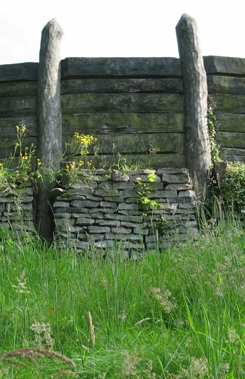
The hillfort begins approx. 2.3 km south-east of Oerlinghausen at the top of the elongated ridge of the Tönsberg. It is a ground monument worth seeing with clearly recognizable remains of a prehistoric fortification. Some maps also refer to it as "Sachsenlager". The signposted "Archaeological Hiking Trail" starts at the Archaeological Light Museum in Oerlinghausen and leads along the ridge path of the Tönsberg (part of the "Hermannsweg") to the information boards of the ground monument. These provide information about the most striking parts of the site and explain the significance of the former rampart castle. The rampart ditch system consisted of various ramparts, ditches and terraces. In the west of the hill, a rampart over 10 meters wide and four meters high stretched over a length of 180 meters. In the Latène period, the main rampart consisted of a three-metre-high wooden plank wall with an attached breastwork made of wattle and daub and an earth embankment behind it. In the early Middle Ages, the main rampart was a double-shelled mortared stone wall about 1.6 meters thick. The entrances to the rampart were once protected by two chamber gates. Various traces of settlement have been found inside the fortifications, which were around 440 m long and between 80 and 180 m wide. Stone remains of a building from the early Middle Ages were also found, which extended over a length of 21.6m and a width of 8m. However, nothing is known about the function of the house. Next to it was a chapel called the "Hünenkapelle" or "Tönskapelle". Pilgrimages to the Tönsberg are said to have taken place in the 15th century. The Paderborn annals report on a pilgrimage chapel of St. Anthony, in which the St. Hülffe cross was worshipped. This now 900-year-old oak cross with corpus is now worshipped in the Paderborn cathedral crypt.

Due to its outstanding significance, the Wallburg has been an archaeological and biological conservation zone since 2004.

A visit to the rampart castle on the Tönsberg is not only worthwhile from an archaeological point of view, but also offers beautiful views of the Lipper Bergland and the Senne as a special scenic attraction. Below the Hünenkapelle is the Wistinghaus Gorge and opposite is the Huneckenkammer, which rises 325 m above sea level. You can also see the Wistinghausen estate and the district of Währentrup from up here.

Good to know

Best to visit

suitable
Depends on weather

Directions

Get the information flyer "Wallburg Tönsberg" at the Archaeological Open-Air Museum or print out the map here, as some path markings are missing.

Equipment

Sturdy shoes and clothing suitable for the weather

Binoculars


Directions & Parking facilities

Via A33 - Exit 22, Schloß Holte-Stukenbrock - turn right towards Oerlinghausen L751 - after approx. 5.6 km (after tunnel) turn left onto L751/exit towards Oerlinghausen - turn left onto L967/Zeppelinstr. - after approx. 100 m at traffic lights turn right onto "Robert-Koch-Str." towards glider airfield - after approx. 600 m turn left onto "Welschenweg" - turn left onto "Triftweg" - after approx. 100 m parking lot at the museum Via A2 - exit 27, Bielefeld Zentrum - B66 towards Oerlinghausen - exit towards Oerlinghausen - after approx. 4.7 km on L751/exit right towards Oerlinghausen - turn left onto Zeppelinstr. - after approx. 400 m at traffic lights turn right onto "Robert-Koch-Str." towards glider airfield - after approx. 600 m turn left onto "Welschenweg" - turn left onto "Triftweg" - after approx. 100 m parking lot at the museum
Oerlinghausen - Archaeological Open-Air Museum, Am Barkhauser Berge 2-6
Line 34 stop Kastanienkrug > around the Kastanienkrug > street "Welschenweg" > right street "Triftweg" after approx. 100 m Museum

Line 39 stop Friedrichstr. > towards Kastanienkrug > street "Welschenweg" > right street "Triftweg" after approx. 100 m Museum

Additional information

www.oerlinghausen.de

www.afm-oerlinghausen.de


www.naturpark-teutoburgerwald.de


Book tip: Tönsberg bei Oerlinghausen - Lippische Kulturlandschaften Heft 7, 1st edition 2007 ISBN 978-3926311-49-8A reconstruction of the Tönsberg fortification can be seen in the Lippisches Landesmuseum in Detmold.


Author´s Tip / Recommendation of the author

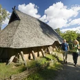
A visit to the Oerlinghausen Open-Air Archaeological Museum is highly recommended

Safety guidelines

From the open-air museum in the direction of the archaeological hiking trail, there is a steep incline of approx. 100 meters in altitude over a distance of 400 meters - partly a trail

Nature reserve - please do not leave the designated paths!
Getting there
Oerlinghausen - Archaeological hiking trail
33813 Oerlinghausen