Hummerser Rundwanderweg mit rustikalen Bänken


- 4:58 h
- 17.43 km
- 356 m
- 358 m
- 171 m
- 310 m
- 139 m
- Start: Hummersen fire station
- Destination: Hummersen fire station
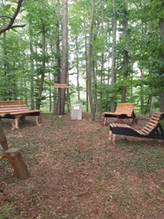
The following benches and shelters are located along the route:
- Hummerser Busch refuge
- Hummerser treetop meditation area
- Bench at the Silbersiek pond
- Seating area on the peninsula
- Wood swivel folding bench
- Semi-circular bench at the Congo Hut
- Up'n Austerhan
- Up'n Rauen Felde
- Up'n Ziegenowe
- Am kleunen Kotterberge
- Gong sitten un soi teofrie
- Up'n Schweinestallen
- Spitzhütte
- Johannesbank
- Border bank
- Mill path bench
- View to Meilborssen
- Fire station bench
- Pensioners' bench and bench for socializing
The benches along the path were built by Heinz-Friedrich Müller from Hummersen on a voluntary basis and installed with the support of the village community.


Waypoints
Good to know
Pavements
Best to visit
Directions
On this circular hiking trail, there are rustic wooden folding benches at scenic spots that invite you to linger.
The circular trail starts in the direction of "Mühlenberg". It leads to Poller Straße, along the Lakenbach stream, past the "Hummersen Busch" refuge to "Dorn". There along the Wakdesrand to Falkenhagener Straße. The trail continues downhill past the "Bergwerksdreher" to the "Silbersiekteich". Follow the path above the pond to the peninsula, where a seating area invites you to linger. Now the path runs through the nearby fir forest along the "Molkenkielweg", to the "Osterhagenweg" to the edge of the forest, "Klingelborner Weg" up to the cabbage garden with the "Holzdrehklappenbank", From there you can enjoy an extraordinary view for miles into the Solling, to the Lth, into the Lipperland with Köterberg, without twisting your neck, The circular hiking trail continues over the "Osterhagen" to the "Rote Feld". From there, take the "Köterbergstraße" and the "Nieser Kirchweg" towards "Ziegenau" with its folding bench. Here you will see a memorial plaque that provides information about the history of goat farming in Hummersen and Niese. Now cross Köterbergstraße in the direction of "Buchholz" where the path leads to the small Köterberg. From there you pass the cemetery, outdoor pool, along the Vogelsang and shooting range to the "Schweineställen". The trail continues over the "Wiehenberg" to the Lower Saxony border, past the Spitzhütte to the "Bahnhof". A long straight section takes you past the "Forsthaus Ziegelei" to the "Golfwirtschaft" inn. From there in the direction of "Kuhkamp", around the golf course, along the state border in the direction of "Mühlenweg", you will return to the starting point.
Tour information
Loop Road
Directions & Parking facilities
Additional information
More information
Contact person
License (master data)
Tourist-Information Lügde

Safety guidelines
Download GPX file
Photo Gallery


