Enger Bruch und Sattelmeierhöfe - N&K Route 11


- 2:38 h
- 10.68 km
- 45 m
- 41 m
- 84 m
- 136 m
- 52 m
- Start: Public parking lot, Bolldammstraße 36, 32130 Enger
- Destination: Public parking lot, Bolldammstraße 36, 32130 Enger
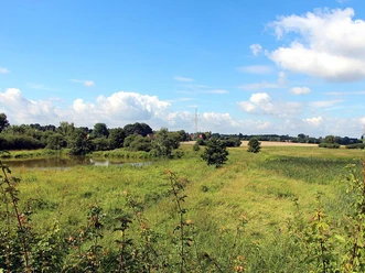
After heavy rainfall, the meadows and tall shrubs are flooded for many weeks. The surrounding farmland is usually much higher, whereas commercial and residential areas are sometimes not. Today, the quarry is of great importance as a breeding area for water birds and is also a valuable resting place for migratory birds, a "hotspot" for bird migration.

Logo_Natur_und_Kultur_v2.png
Logo_Natur_und_Kultur_v2.png
Logo für "Natur & Kultur im Kreis Herford" mit stilisierten Figuren in Blau und rotem Kreis.
Waypoints
Start


Good to know
Pavements
- Street (10%)Asphalt (15%)Gravel (5%)Trail (40%)Trackless (30%)
Best to visit
- suitableDepends on weather
Tour information
Cultural Interesting
Loop Road
Mainly Sunny
Nature Highlight
Stop at an Inn
License (master data)
Touristikgemeinschaft Wittekindsland e.V.

Download GPX file
Photo Gallery


