Berinkhusenweg

15.73 km long
Round trip
Difficulty: medium
Condition: medium
Regional hiking trail
  • 4:47 h
  • 15.73 km
  • 414 m
  • 423 m
  • 116 m
  • 294 m
  • 178 m
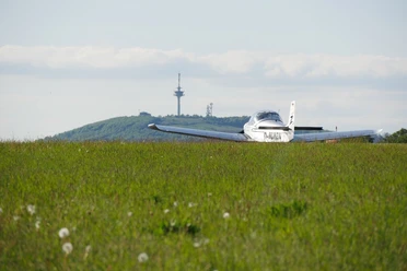
  • Start: Hikers' parking lot just before the airfield on the Räuschenberg (Höxter-Brenkhausen)
  • Destination: Hikers' parking lot just before the airfield on the Räuschenberg (Höxter-Brenkhausen)
Varied circular hiking trail around the Höxter district of Brenkhausen. Narrow forest paths, field paths and meadow paths alternate. In addition, there are always new views over the landscape, the Brenkhausen monastery complex and the calcareous grasslands on the Räuschenberg.

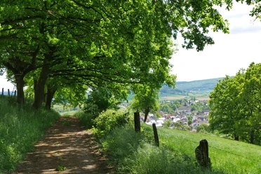
The varied hike around Brenkhausen starts north-east of the village at the "Räuschenberg" nature reserve. The sunny slopes of the Räuschenberg are traditionally grazed by goats. While in spring you can marvel at the colorful flowers, in summer oregano and thyme provide a Mediterranean flair with their aromatic scent.

The interplay of short, steep climbs and the wide views of the landscape that open up are what make this 16 km circular tour so special. There are also narrow, winding forest paths and trails along meandering streams. The small-scale landscape with individual farms and pastures is often divided by hedges, which are particularly important for birds and wildlife.

The view of the Brenkhausen monastery complex is also impressive. Today, the General Bishop of the Coptic Orthodox Church in Germany has his headquarters here. Monastic life is blossoming anew here in the spirit of ecumenism and hand in hand with the Catholic Church. Be sure to plan a visit and experience oriental hospitality and warmth for yourself.

A special thanks goes to the Wanderfreunde Schelpetal, who not only mark the path well but also regularly cut it free.

Waypoints

Start
Hikers' parking lot just before the airfield on the Räuschenberg (Höxter-Brenkhausen)
Ein kleines Flugzeug steht auf einer grünen Wiese mit dem bewaldeten Köterberg und einem Funkturm im Hintergrund.
CC-BY-SA | Kulturland Kreis Höxter, Katja Krajewski
Blick auf den Flugplatz am Räuschenberg
Vantage point/Observation tower
Grüner Waldweg entlang eines kleinen Baches mit einem rustikalen Holzgeländer, umgeben von dichter Vegetation.
CC-BY-SA | Kulturland Kreis Höxter, Katja Krajewski
Entlang der Schelpe
Nature discovery trail

Good to know

Pavements

Unknown
Street
Asphalt
Gravel
Trail
Path

Best to visit

suitable
Depends on weather

Directions

The path is well marked with the Wartturm logo. In the meantime, a green dot supplements the markings.

Route markings

The path is well marked with the Wartturm logo. In the meantime, a green dot supplements the markings.

Tour information

  • Cultural Interesting

  • Labelling

  • Loop Road

  • Stop at an Inn

Equipment

Well-fitting hiking boots and a regional picnic for the breaks.

Directions & Parking facilities

Follow the signs to the airfield on the Räuschenberg. Before you reach the café, there is a free parking lot for hikers on the right-hand side.
There is a free parking lot for hikers at the starting point.

Contact person

Kulturland Kreis Höxter
Corveyer Allee 7

License (master data)

Kulturland Kreis Höxter
License: Attribution, ShareAlike

Author´s Tip / Recommendation of the author

At the end of the tour, treat yourself to a piece of cake at the airfield and enjoy the view.

Map

The trail is marked BH0 on the hiking map 69 Höxter Nord of the Eggegebirgsverein.

Our recommendations

Ein Weg mit Bäumen führt zu einem Dorf in einer sanft hügeligen, grünen Landschaft.
CC-BY-SA | Kulturland Kreis Höxter, Katja Krajewski
Wunderschöner Blick auf Brenkhausen
Vantage point/Observation tower

Contact

Berinkhusenweg
Wanderparkplatz Bratvogelweg
37671 Höxter - Brenkhausen
Bad Salzuflen: feel-good place
Our tip

Nature without detours

© Teutoburger Wald Tourismus / D. Ketz
Experience nature
Our tip

Exciting quality hiking trails

© Touristikzentrum Westliches Weserbergland
Favourite time out in nature

Rheda-Wiedenbrück

© Teutoburger Wald Tourismus / D. Ketz

Photo Gallery