Altenau-Radweg


- 2:20 h
- 28.09 km
- 80 m
- 328 m
- 127 m
- 372 m
- 245 m
- Start: Lichtenau-Blankenrode, Altenau spring
- Destination: Nordborchen, Altenaum estuary
The Altenau cycle path is perfect for a varied family excursion on two wheels. Away from major roads, the route leads through the idyllic Altenau valley with its green meadows, small villages and the babbling Altenau river as a constant companion. There is plenty to discover along the way: historic village centers, impressive churches, quaint half-timbered houses and exciting traces of the past that tell of the valley's long history.
The cycle path follows the course of the Altenau for around 28 kilometers from its source in Blankenrode to where it flows into the Alme near Nordborchen. Numerous rest stops, cozy cafés and family-friendly excursion destinations ensure that young cyclists also get their money's worth along the way. A particular highlight is the imposing Dalheim
Dalheim monastery complex, which is well worth a detour.
+++ Current information +++
Closure of the cycle path due to construction work until probably the end of 2027:
A new waste water collection pipeline is being built between Etteln and Kirchborchen. In future, this pipeline will be used to transport wastewater from Etteln to Kirchborchen and from there to the sewage treatment plant. The project will begin in mid/end June 2026 and will last until the end of 2027. Unfortunately, this will also affect the popular Altenau hiking trail. A detour is signposted.
Further information on the detour:
https://www.borchen.de/de/gemeinde/bauen-wohnen/Neue-Schmutzwasserleitung-etteln.php
https:// umap.openstreetmap.de/de/map/umleitung-altenau-radweg-20262027_141674#13/51.646359/8.717480

Good to know
Pavements
- Street (31%)Asphalt (15%)Gravel (54%)
Best to visit
- suitableDepends on weather
Directions
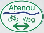
- The Altenau Cycle Path is marked at many prominent points with its own route signs: an oval signpost with a stylized blue river and green print on a white background. The route is marked with green arrows in both directions.
The easiest way to cycle the Altenau cycle path is downstream from the source in Lichtenau-Blankenrode to Nordborchen and possibly further along the Alme to Paderborn: Blankenrode - Husen - Atteln - Henglarn - Etteln - Kirchborchen - Nordborchen
Route markings
- The trail is marked throughout ("Altenau Weg"; green lettering on a white background)
Tour information
Familiy-Friendly
Stop at an Inn
Suitable for Bike
Directions & Parking facilities
- Getting thereA 44, exit Lichtenau/Meerhof, continue towards Lichtenau, then turn right towards BlankenrodeParkingParking lot in Lichtenau-Blankenrode (Hardhauser Straße), in the immediate vicinity of the Altenau springsPublic transportationBus stop: "Li-Blankenrode" (bus routes 487, 488, 489)
Timetable information:Paderborn/Höxter local transport association (nph)Phone +49 5251 2930400 | www.fahr-mit.de Additional information
Documents
License (master data)

Author´s Tip / Recommendation of the author
- If you still have time at the end of the route, you can switch to the Alme cycle path (the Altenau flows into the Alme in Nordborchen) and cycle comfortably to Paderborn-Schloss Neuhaus.
Safety guidelines
- Always pay attention to the road safety of your bicycle. For your own safety and as a role model, we recommend wearing a bicycle helmet.
Map
- Cycling map:
"Die schönsten Radtouren im Paderborner Land"
Scale 1:50,000 | ISBN 978-3-96990-031-4
Publisher: BVA Bike Media GmbH
Download: Flyer Altenau-Radweg >> Social Media
Our recommendations

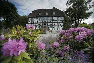


Photo Gallery


