The Wolkensteig in Oerlinghausen A7


- 1:30 h
- 5.23 km
- 171 m
- 38 m
- 159 m
- 297 m
- 138 m
- Start: from the south: glider airfield, Stukenbrocker Weg 43, Oerlinghausen or in the opposite direction: Kumsttone Oerlinghausen, Kammweg
- Destination: Kumsttonne Oerlinghausen, Kammweg or glider airfield Oerlinghausen, Stukenbrocker Weg 43
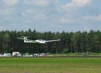
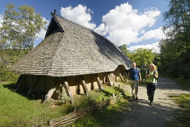
Past the glider airfield, the trail leads through the forest grazing area (see Ox tour / lizard trail), the Hassler sand pit and the limestone quarry with a wonderful view of the steep walls with their sloping limestone layers. The quarry itself is a habitat for the eagle owl and the rare natterjack toad and is kept open by grazing goats. Passing the open-air archaeological museum, you reach the ridge path of the Tönsberg (334 m above sea level) with the Kumsttonne, the landmark of the mining town of Oerlinghausen, visible from afar. The mill from 1753 lost its wings in a storm and remained standing on the mountain in this condition. The name "Kumsttone" is derived from Kumst for sauerkraut, as Stumpf resembles a sauerkraut barrel.


Waypoints

Good to know
Pavements
Best to visit
Directions
From the starting point: glider airfield, please follow the trail markings (A7/cloud) through the grazing area (Ochsentour/Eidenpfad), through the Hassler sand pit, limestone quarry - past the open-air archaeological museum (coinciding with the course of the X10) on the ridge path of the Tönsberg to the Kumsttonne
Tour information
Stop at an Inn
Equipment
Directions & Parking facilities
A33, exit 22, L751 direction Oerlinghausen, follow the signs "Segelflugplatz"
A2, exit 27, B66 direction Oerlinghausen, L751 direction Oerlinghausen, follow the signs "Segelflugplatz"
Additional information
www.ngpsenne.de (you can also download an app for the hiking trail here)
License (master data)
Bettina Schneider

Author´s Tip / Recommendation of the author
Safety guidelines
Nature reserve! Please do not leave the designated paths!
Please observe the rules of conduct in the grazing area!
Map
Oerlinghaus hiking map "Hiking experience"
We recommend that you take the "Oerlinghauser Erlebnisguide" with you. The local hiking trails are described here in detail and informatively.
You can obtain the map and brochure from the tourist information office or download it from the homepage.
Photo Gallery


