- 2:59 h
- 10.26 km
- 216 m
- 216 m
- 164 m
- 275 m
- 111 m
- Start: Seminar center Haus Neuland
- Destination: Seminar center Haus Neuland
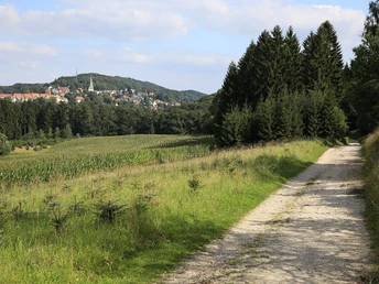
From the former Fichteheim forest restaurant, you walk steadily uphill until you reach a wide fort road exactly 200 m above sea level. The route is almost flat - passing under a high-voltage power line - to Markengrund. Once you reach the southern variant of the Hermannsweg, the Neuland hiking trail leads you along the southern slope of the limestone ridge. At every turn, you will experience a constant change between sand and limestone. After a few twists and turns, the trail reaches its highest point at 250m above sea level. Now you walk just under 250m next to the Autobahn A2. Afterwards, a very special natural monument awaits you: a lime dry grassland, which is a nature reserve due to its rare animal and plant species.
From Gasthaus Deppe (228 m above sea level), a longitudinal valley stretches south of the hiking trail between the central and southern ridges of the Teutoburg Forest. On the north side is the Bielefeld district of Lämmershagen, a medieval settlement founded by the Ravensberg lords. To the south, you have an unobstructed view of the chalk limestone ridge, which is characterized by atmospheric ups and downs. Along the hiking trail there are several houses (nos. 41 and 48) from the early 20th century, which were built from the Osning sandstone quarried here.
TIP: North of the point where the two parts of the Hermannsweg meet again, there is a major geological feature: the Osning sandstone here contains single-ore seams, and coal is also found here. The fact that mining was once carried out here is still documented today by street names such as Kohleweg. A wide, increasingly sandy path branches off to the south in the direction of Markengrund. Marken were communally used agricultural or forestry areas.
Our path bypasses the Brinkmann farm in the middle of the valley, where sand was mined in recent decades. As you continue, you have a view of the charming silhouette of the town of Oerlinghausen.Down to the Schopketal, you will come across a burial mound south of the path, which is one of around 250 graves in the Lippe part of the Senne. The trail then follows the nature reserve "Menkhauser Bachtal mit Schopketal" (185m above sea level) with rare flora and fauna.
Info: The Menkhauser stream is one of the few streams with a sufficient volume of water that originates in the Teutoburg Forest and, together with small tributaries, carries water into the Senne all year round.
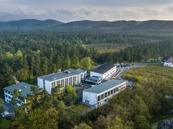
Our path continues for approx. 800m through the deep valley, then crosses the stream and climbs a short distance in between. At just 160m above sea level, you reach the lowest point of the hiking trail at Haus Neuland.
Good to know
Pavements
Best to visit
Directions
Course of the trail:
Start at the Haus Neuland seminar center: from the former Fichteheim forest restaurant steadily uphill - continue to a wide forest road - under a high-voltage power line to Markengrund. Once you have reached the southern variant of the Hermannsweg, continue along the southern slope of the Kalksandstein ridge. After a few bends, the highest point of the trail is reached: 250m above sea level. Continue along the A2 highway for approx. 250 m until you reach the Deppe inn (228 m above sea level) - keep right here. Follow the Hermannsweg - bypass the Brinkmann farm in the middle of the valley - continue down to the Schopketal valley. Follow the path to the nature reserve "Menkhauser Bachtal mit Schopketal" (185m above sea level) - continue for approx. 800m through the valley - cross the stream - walk up a short distance to the starting point (160m above sea level).
Tour information
Loop Road
Stop at an Inn
Equipment
Directions & Parking facilities
NAVIGATION ADDRESS ( Seminar Center Haus Neuland)
Senner Hellweg 493
33689 Bielefeld
By bus and train
At Bielefeld main station, take the train to Oerlinghausen station. Trains usually run every half hour. However, due to a major construction site in Oerlinghausen, there will be restrictions from 2018, which will also affect rail services. The current timetables can be found on the website of Deutsche Bahn.
By prior arrangement, we will be happy to organize a transfer from Oerlinghausen train station to Haus Neuland for a fee.
If you are traveling to Haus Neuland by bus, take the 135 line in Bielefeld-Senne and get off at the "Württemberger Allee" stop. From there, you can reach Haus Neuland on foot in around 25 minutes (3 kilometers). You can find the timetables here:
Arrival (Senne - Württemberger Allee): Download the timetable
Departure (Württemberger Allee - Senne): Download timetable
or on the website: www.haus-neuland.de/anfahrt
Additional information
Literature
Hiking flyer: The Neuland hiking trail
Author´s Tip / Recommendation of the author


