Erlebnis.Kreis.GT: Hike to Ravensberg Castle and the Luisenturm Borgholzhausen

- 4:00 h
- 10.97 km
- 291 m
- 291 m
- 113 m
- 277 m
- 164 m
- Start: Borgholzhausen Town Hall, Schulstraße 5
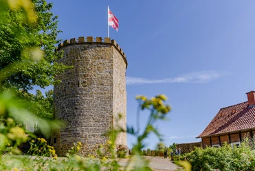
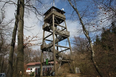
The approximately 11-kilometre hike runs along the heights of the Barenberg through the Clever Gorge to Ravensberg Castle. Ravensberg Castle has been extensively restored in recent years and offers a magnificent view of the Ravensberg hills. You can relax in the restaurant at Ravensberg Castle and recharge your batteries for the next stage. Because now the route continues to the Luisenturm tower on the 291 m high Johannis-Egge. In fine weather, you have a wonderful view over the Teutoburg Forest, the vast Münsterland and the Ravensberg hills. You can stop for coffee and cake in the Luisenturmhütte restaurant before continuing on to the starting point, Borgholzhausen town hall.


Waypoints
Good to know
Pavements
Best to visit
Directions
From the town hall parking lot at Schulstraße 5, first turn left into the street "Masch" and walk past the outdoor pool. After a few meters you will find yourself on the street "Vogelgitter", which you then turn right and follow. Cross the Haller Weg and you will reach the street "Großes Moor" . Follow the small path straight ahead in the left-hand bend. Accompanied by the Violenbach stream, turn right at the junction and follow Hamlingdorfer Weg straight ahead. After just a few meters, you will reach Barenbergweg, which you take on the left. Keep left at the fork and continue straight ahead on Hindenburgweg. Shortly before the right-hand bend, take the small path on the left, which leads you onto the ridge path of the Teutoburg Forest. Follow this straight ahead. At the first fork, turn left and stay on the path. Two small crossroads follow, which you cross straight ahead. At the third junction, keep left into the Clever Gorge. At the next fork, continue right onto the Hermannsweg, which will take you to Ravensberg Castle.
After a rest at the castle, take the Hermannsweg again, which now leads downhill. Follow the path and then turn left onto Barenbergweg. At the end, turn right onto the road "Unter der Burg". After about 70 m, keep left onto Nollheide. At the end, turn right along Bahnhofstraße for about 150 m and then cross the road to the left to reach Nollbrink. At the next junction, turn right into Wellenstraße. At the T-junction, turn right onto Berghauser Weg. Follow this road for about 100 meters, then keep left. It now goes steadily uphill. Stay on the path until you reach a left-hand bend. There is a narrow path on the right-hand side of the bend, which you follow until you reach the Luisenturm tower.
To return to the starting point of the hike, return to the path that brought you to the Luisenturm. Follow the downhill path through the forest. At the clearing, leave the forest and continue straight ahead past fields. Keep right at the fork and from there you will reach the mountain road, which you follow to the left. Cross Wellingholzhauser Straße and stay on Bergstraße. Take the small path on the right that follows Konradstraße. Stay on the path and cross Teutoburger Straße. You will then come to the street "Klingenhagen". Turn left here and you are back on Schulstraße, which leads you to the parking lot.
Tour information
Cultural Interesting
Loop Road
Stop at an Inn
Equipment
Directions & Parking facilities
.
Additional information
License (master data)
pro Wirtschaft GT GmbH und Teutoburger Wald Verein /

Author´s Tip / Recommendation of the author
Safety guidelines
Download GPX file
Photo Gallery


