Erlebnis.Kreis.GT - Circular hike to Jakobsberg and along the Hermannsweg in Steinhagen

GPX

PDF

Bookmark

9.86 km long
round trip
Difficulty: medium
condition: medium
Regional hiking trail
  • 02:52 h
  • 195 m
  • 199 m
  • 142 m
  • 305 m
  • 163 m
  • 9.86 km
  • Start: Quellental Mountain Hotel
  • Destination: Quellental Mountain Hotel
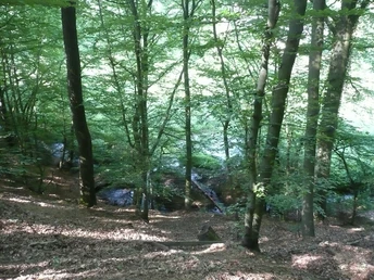
This approximately 10 km long circular walk invites you to the north of Steinhagen. It takes you to the Jakobsberg, where the rare liverwort is in full bloom in spring, and leads you up to the Bußberg, 306.2 m above sea level. Many beautiful viewpoints are guaranteed!

The Berghotel Quellental in Steinhagen is a great starting point. From here, the circular tour initially leads along the Leberblümchenweg towards Jakobsberg. On the way, you can take a short break at the gourmet rest area on the hiking trail of the same name. The "Jakobsberg" nature reserve is known for its liverworts, thousands of which bloom there in spring. From here, you pass the Friedrichshöhe restaurant and continue along the so-called Schwedenschanze up to the Bußberg. Here you can take a break at the Kaiser-Friedrich memorial hut. If the weather is good, you will be rewarded with wonderful views of the Ravensberger Hügelland and Bielefeld-Dornberg. The route now continues along the Hermannsweg. You reach the mountain road, which you cross at the Wald-Hotel Peter auf'm Berge and walk directly alongside the Wald-Hotel. From here it is not far to the starting point. You can round off your hike in comfort at the Berghotel Quellental.

Good to know

Best to visit

suitable
Depends on weather

Directions

You start at the Berghotel Quelletal in Steinhagen. From here, walk in the direction of Bielefelder Straße, which you cross. You are now on the A7 Quellental hiking trail, which you follow until you come to a fork. You are now on the Schwedenpatt, the A7 now leads to the right. However, you go straight ahead onto the road "Am Bußberg" and follow the hiking trail "Weg für Genießer" (red sign with a white G). Walk along "Sürenbrink" for a while until the path meets Kaistraße. Turn left here and then immediately right again. But be careful! Take the left-hand path of the two junctions and stay on the "Weg für Genießer". You can take a break at the Friedrichshöhe restaurant or follow the red signposts with the white G for the Genießerweg. Follow the "Tiefen Weg" through the forest, then leave the path on the left and follow the A1 hiking trail. Now there is an ascent to the junction with the Hermannsweg. Follow this to the right. After passing the Kaiser-Friedrich-Gedächtnishütte hut, the trail briefly descends a little before climbing again, but only slightly. You are still on the Hermannsweg. Now it's downhill to the Wald-Hotel Peter auf'm Berge. Here you cross Bielefelder/Berg Straße and continue on the ridge path behind the hotel for 200 meters. Then leave the Kammweg or Hermannsweg and take the right-hand path at the crossroads, which is marked "Wappenweg Bielefeld". Now you don't have to walk a short distance along the path through the forest, turn right twice and then come to the Am Sennberg path. Turn left here and then immediately right again. You are now back on the A7 Quellental hiking trail. This is the last 400 meters of the tour, as you have now arrived back at the starting point, the Berghotel Quelletal.

Tour information

  • Loop Road

  • Stop at an Inn

Equipment

Sturdy shoes and appropriate clothing depending on the weather.

Directions & Parking facilities

Berghotel Quellental, Quellental 10, 33803 Steinhagen

Additional information

Author´s Tip / Recommendation of the author

The restaurant "Friedrichshöhe" invites you to a breakfast buffet on Sundays from 10 am. When the weather is fine, you can also linger outside.
Getting there
Erlebnis.Kreis.GT - Circular hike to Jakobsberg and along the Hermannsweg in Steinhagen
33803 Steinhagen
Bad Salzuflen: feel-good place
Our tip

Nature without detours

© Teutoburger Wald Tourismus / D. Ketz
Experience nature
Our tip

Exciting quality hiking trails

© Touristikzentrum Westliches Weserbergland
Travel planning on the road

Teuto-Navigator ►

© Teutoburger Wald Tourismus / D. Ketz