- 2:40 h
- 8.31 km
- 21 m
- 108 m
- 106 m
- 206 m
- 100 m
- Start: Parking lot "Eisgrund"
- Destination: Wilhelmsdorf Estate
The hiking trail is signposted with the regional hiking trail sign "Raute 3" and the subtitle "Bullerbachtalweg". The tour starts at the "Eisgrund" bus stop on bus route 30 (hikers' parking lot). On this first section, the Bullerbachtalweg runs like the A2: if you follow the path opposite the parking lot in a southerly direction (Senne), you will see the Eisgrundsberg on the left and a stream valley on the right, for which no name has been established. Its water will seep away after a short distance, but fills the catchment area of the Bullerbach, which rises two kilometers southwest of here.
The path leads through the "Fuchsröhre" under the freeway; next to the freeway, it goes downhill for 400 meters. At the retention basin, before the hikers' parking lot, turn left. The retention basin to the right of the path was built to prevent flooding in the northern part of Sennestadt, which occasionally occurred at the end of winter until the 1990s. Surface water from the freeway is collected in the retention basin, pre-cleaned and released in an "orderly" manner.
After about 1 km on forest paths, you reach the Senner Hellweg and thus the northern edge of Sennestadt. After crossing the Senner Hellweg, turn into the cul-de-sac that leads to Frieda-Nadig-Haus. A footpath leads downhill to the right in front of this retirement home. Past the "Mordsteinen", a cultural monument from the period after the Thirty Years' War (on the left, close to the Frieda Nadig House) and the barbecue hut (at the bottom of the slope), you reach a small pond and walk past it on the right and between sports facilities to Travestraße.
The heart of the Bullerbachtalweg begins opposite. After crossing Travestraße, the footpath leads down to the gorge valley of the Bullerbach. An observation pulpit was built at the beginning of the valley in 2001 and a natural history information board was erected. From the pulpit, you can see into the gorge of the Bullerbach and observe the seepage springs.
Excursion: History of the Bullerbach spring
"Surface runoff and escaping groundwater have carved typical talc trenches into the landscape in the Senne. In turn, the wind blew up mighty dunes. Both could be found here at the source of the Bullerbach stream. The dune - located above Travestraße - was removed in the 1930s for the construction of the highway, and at the same time the water was removed from the spring slope by a drainage ditch. In the 1970s, the spring area was built up with a massive protection of stones and concrete. The local conservationist Ernst Neumann and many other committed citizens have always campaigned for the renaturation. In 2001, the source of the Bullerbach was restored." (Plaque at the Bullerbach spring)
The hiking trail now leads along the left edge of the valley, from where you can get a good view of the valley, which is initially cut 10 meters deep with many old trees. From here, you can also see the Jesus Christ Church on the opposite side. This path ends in the center of Sennestadt at the access road to Reichowplatz and Lindemann-Platz, which crosses the Bullerbach between the park pond and the town pond. One day, this access road will hopefully be designed in such a way that the Bullerbach becomes visible.
Variant: From the source, pedestrians can also reach the center on the right side of the Bullerbach. The footpaths bypass several dry valleys that lead to the main valley. This variant is more complicated, but very scenic with many views of the Bullerbach, small footbridges and dry valleys.
At the access road, go straight on towards the small staircase that leads past the Haus der Jugend (LUNA) along the Sennestadtteich pond and thus on the side of the Sennestadthaus facing the pond and further along the Stadtteich pond to the "Sennestadtring" bus stop. There you cross the Sennestadtring. On a small path - a project of the Stadtumbau West - it goes up to the bridge over Paderborner Straße (L756). On the bridge, cross the L756 and turn left over the pedestrian island between Sprungbachstraße and Altmühlstraße onto the footpath into Bullerbachtal.
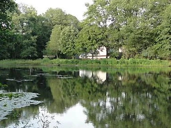
Once again you look out over the indented valley and soon onto idyllic ponds. Where the wide footpath ends at the crossroads (between the ponds), continue straight ahead on the hidden path next to the beautiful mill pond of the former Westerwinter sawmill until you branch off to the half-left - along allotments and a footpath along the Senne-Bahn railroad track.
You leave the Bullerbach for a short time to reach the track crossing. After crossing the track, turn right into Sender Straße, which you follow until you reach the Bullerbach again. There, behind the Hotel Wintersmühle (the former building of the corn mill on the Bullerbach), turn left along the pond until you reach the right fork of a footpath and cycle path that leads under the A33 highway. Shortly after this underpass, continue straight ahead along the edge of the meadow (on the banks of the Bullerbach), i.e. do not follow the gravel path that soon turns off. This section, which ends at Fliednerstraße, has been newly created for the Bullerbachtalweg. Now cross the Bullerbach to the left and continue to the right on the hidden footpath on the route shared with the Sennestädter Rundwanderweg to the center of Eckardtsheim. On the way to Eckardtskirche church, a few steps to the right of the path is the confluence of the Bullerbach and Sprungbach streams, which can be seen from the bridge on Werkhofstraße. From here, we speak of the Dalkebach.
Past the Eckardtskirche church, continue straight ahead under the venerable old oak trees to the junction with Verler Straße. A small stile diagonally opposite leads (hidden) to the grounds of the Wilhelmsdorf estate, where you can soon see the organic farm store on the right, the official end point of the hike, which is indicated by a sign.
Good to know
Best to visit
Directions
Course of the trail:
Parking lot "Eisgrund" (Lämershagener Straße) - Senner Hellweg - Mordsteine von 1660 - Grillhütte - swimming pool - Bullerbachquelle - Schluchttal - Parkteich - Sennestadtteich - Mühlenteich - Sender Straße - Winters Mühle - underpass A33 - Fliednerweg - Eckardtsheim - Eckardtskirche - Gut Wilhelmsdorf
Directions & Parking facilities
Lämershagener Straße, 33699 Bielefeld
Parking lot "Eisgrund"
The starting points can be reached with moBiel lines:
Line 30 ("Eisgrund")
Line 37 ("Wilhelmsdorf")
In Sennestadt, the Bullerbachtalweg touches several other stops on lines 30 and 135.
Always know what's running: the smart number for buses and trains in NRW 01806 504030
( 20 cents/connection from landlines and a maximum of 60 cents/connection from mobile networks)
Additional information
Literature
License (master data)
Author´s Tip / Recommendation of the author


