Alter Pilgerweg Paderborn - Auf den Spuren von Pilgern und Kaufleuten


- 5:00 h
- 20.86 km
- 406 m
- 406 m
- 156 m
- 284 m
- 128 m
- Start: Paderborn, Haxtergrund (parking lot at Bistro Waldklang)
- Destination: Paderborn, Haxtergrund (parking lot at Bistro Waldklang)
The small chapel "Zur Hilligen Seele" south of Paderborn has been a place of deep devotion to the cross for more than 1,000 years and is therefore the destination of numerous pilgrims and pilgrimages. As the only relict of the former Saxon settlement of Eilhardinghausen, it stands idyllically under ancient, shady lime trees in the landscape of the Paderborn plateau.
This approximately 21 km long circular hiking trail follows in part the footsteps of pilgrims who made a pilgrimage to the Hillige Seele via the "Via Regia", an army and trade route that has existed since the Middle Ages. The "Frankfurter Weg", as the "Via Regia" has been called since the 17th century, was also used by Paderborn's prince-bishops and merchants for their journeys to Frankfurt, the imperial coronation and trade fair city.
The starting point of this hike is the Haxtergrund, a popular local recreation area for the people of Paderborn, which is crossed by the Ellerbach stream. The trail first leads along the northern edge of the valley to the "Stern", a crossroads of old paths. From there, it continues along the Ellerbach stream to Hamborn Castle. Through the secluded Despental valley, it first goes up to the northern edge of the Altenau valley to the striking "Teufelstein" viewpoint, then down into the valley to the baroque Kluskapelle St. Lucia chapel on the Altenau. From there, the trail runs through the Bilkental valley, then through a magnificent beech forest, the "Nonnenbusch". A beautiful chestnut avenue leads from the Hillige-Seele chapel down into the valley and after another short ascent, the starting point is soon reached again.


Good to know
Pavements
Best to visit
Directions
From the parking lot at Bistro Waldklang, we first take the asphalt main path. Here we see an information board about the Old Pilgrims' Trail. We turn left and bypass the barrier at the forest school. We then turn right and pass the wooden bridge over the (mostly dry) Ellerbach with the banner of the Old Pilgrims' Trail. At the edge of the forest, at the insect hotel, we keep left and then continue along the gravel path on the right-hand edge of the Ellerbach valley. We follow the asphalt path to the right and head towards the edge of the forest. There we keep left. After the left-hand bend, the asphalt ends and we continue on the slightly ascending gravel path. At a refuge, we keep straight ahead. We continue slightly downhill on a grassy path. We continue along the asphalt path to the left and after a few meters reach the "Stern" crossroads with a picture of the Virgin Mary.
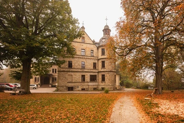
We take the first path on the right and follow the Ellerbach stream for around 300 meters through the valley. At the left-hand bend, we turn right and climb uphill on a gravel path. After about 500 meters, we keep left. Now we can enjoy beautiful views over the Haxtergrund. At the edge of the forest, we turn right. Shortly afterwards, our path becomes asphalted. We walk past the fruit farm and the perennial nursery at Hamborn Castle and reach the crossroads. We cross this. We then keep left and walk along a fairly wide path through the forest. After 400 meters we turn left onto the so-called "Dornröschenweg". We follow this beautiful natural path for about 800 meters. At two houses, we come to an asphalt path and continue to the right. We take a path to the right of house no. 97, which leads us downhill to the asphalt road. Continue along this road to the right.
If we want to take a break at the Alte Schule café, follow the signs for the crossroads of the Old Pilgrims' Trail until then. Specifically, this means that we continue along the road to the left. After 200 meters, we keep to the right and climb up the steps on the slope. At the top, we continue to the right. We can see the castle on the left. After 200 meters, we reach a T-junction where we see the Alte Schule café on the left.
2nd stage: Schloss Hamborn - Kluskapelle "St. Lucia": 5.7 km
At the end of the road, we reach the district road (K 2). We follow this road for about 20 meters to the left and then turn right onto the field path. The path now runs along the edge of the forest through the Despental valley, slightly but steadily uphill. After just under 1.5 kilometers, at an overview board immediately before entering the forest, we turn right.
The path now climbs steeply along the edge of the forest. At the top, the path bends to the right. An asphalt path branches off to the right, we keep straight ahead and continue along the edge of the forest. At the next fork, we keep left and enter the forest. A few meters further on, we again have two options. We decide to take the path to the right. We follow this path past a pine grove, then along the edge of the forest until we come to an asphalt path after a good kilometer. There we turn left. At the beginning of the forest, we come to the small "Hunnewinkel" parking lot. We turn left across the parking lot and keep right at the next fork in the path. The forest path leads downhill past a barrier. We reach a T-junction. Here it is advisable to first take a detour to the right to the Teufelsstein (Devil's Stone), around 150 meters away, which offers us a beautiful view over the Altenautal valley.
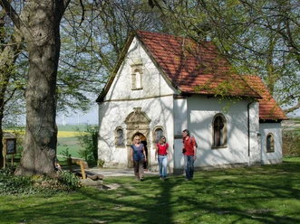
To follow the Old Pilgrims' Trail, we turn left at the T-junction and continue above the Altenautal valley. The path leads around side valleys in two large bends before ending at a T-junction. We turn right and reach the baroque Kluskapelle St. Lucia chapel and the Kapellenhof farm café after just under 400 meters.
(If we don't want to take this detour, we only walk downhill for around 100 meters and then take a sharp left onto the gravel path.)
Stage 3: "St. Lucia" clusters chapel - "Zur Hilligen Seele" chapel: 5.5 km
From the clusters chapel, we walk around 300 meters back along the familiar path to the fork in the path, where we keep right. We now walk about 1.5 kilometers through the beautiful Bilken valley, gently ascending along the edge of the forest. At the end, we turn left and continue along an asphalt path. At the T-junction, which we reach after around 100 meters, we turn right. We follow the forest path for a good kilometer, then turn left onto a natural path. At the T-junction after about 500 meters, we turn right and walk past the Nonnenbusch cemetery forest. On the right in the forest we see the tastefully designed place of worship. To the left, a path leads to the so-called Lindenplatz, which is ideal for a sunny break.
At the crossroads shortly after the construction trailer, turn left. In front of us we see the parking lot of the cemetery forest, on our left a picnic bench, a shelter and an overview board of the Old Pilgrims' Trail. We follow the path along the parking lot and hike to the district road (K 2), which we cross in a straight line. We can already see the "Zur Hilligen Seele" chapel ahead on the right. We continue along the grassy path until we reach an asphalt farm track at the so-called "Karlsplatz".
Stage 4: Chapel "Zur Hilligen Seele" - Haxtergrund parking lot: 4.9 km
After about 300 meters, we see the "Annabild" from 1956 on the left. A little further on, at the fork in the path, we keep left and walk down into the valley through a beautiful chestnut avenue. At the end, turn right. After 300 meters, an asphalt path joins us from the right. Here we turn left and climb up the slope on a natural path. We eventually come to a forest path, which we follow to the right.
At the crossroads near a refuge, we turn left, but after just 50 meters we turn right. Immediately afterwards, we come to a fork. We take the path on the right, which runs along the edge of the forest. In a dip, we follow the 90-degree left-hand bend. At the end, turn right. We leave this path about 50 meters before a barrier to the left and walk down into the valley and back to the starting point.
Tour information
Loop Road
Premium Trail "Wanderbares Deutschland"
Stop at an Inn
Equipment
Directions & Parking facilities
The city bus line 46 (PaderSprinter) runs from the main train station via the city center to the "Vereinshaus" stop in Haxtergrund. The bus runs according to the timetable, but you must call 05251 6997197 (Mon.-Fri. 8 a.m. - 5 p.m.) at least one hour before departure to register your journey, groups of more than eight people at least 24 hours before departure (call line).
Further information on how to get there by city bus is available at www.padersprinter.de or by phone on 05251 6997222.
Additional information
Königsplatz 10
33098 Paderborn
Tel. 05251 8812980
tourist-info@paderborn.de
www.facebook.com/paderborn.tourismus
www.instagram.com/paderborn.tourismus
www.alter-pilgerweg.de
Documents
Literature
Pocketbook "The most beautiful half-day hikes in the Paderborn region and Eggegebirge" with 20 interesting circular tours through the local region (220 pages). Available for 12.95 euros from Paderborn Tourist Information, bookshops (ISBN: 978-3-9809507-8-7) and - free of shipping costs - from HEFT-Zeitschriftenverlag (Tel. 05251 62624).
License (master data)
Tourist Information Paderborn / Verkehrsverein Paderborn e.V.

Author´s Tip / Recommendation of the author
Hike the other Paderborn hiking trails too: the Paderborner Höhenweg, the Paderborner Karstrundweg, the PaderWanderung and the Marienloher Lipperundweg.
Safety guidelines
Social Media
Our recommendations

Download GPX file
Photo Gallery


